IMAGES TAKEN NEAR TO
High Street, SANDY, SG19 1AL
Introduction
This page details the photographs taken nearby to High Street, SG19 1AL by members of the Geograph project.
The Geograph project started in 2005 with the aim of publishing, organising and preserving representative images for every square kilometre of Great Britain, Ireland and the Isle of Man.

There are currently over 7.5m images from over14,400 individuals and you can help contribute to the project by visiting https://www.geograph.org.uk
Image Map
Images are licensed for reuse under creativecommons.org/licenses/by-sa/2.0
Notes
- Clicking on the map will re-center to the selected point.
- The higher the marker number, the further away the image location is from the centre of the postcode.
Image Listing (64 Images Found)
Images are licensed for reuse under creativecommons.org/licenses/by-sa/2.0
Image
Details
Distance
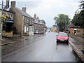
3
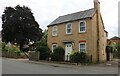
House on High Street, Sandy
This looks Victorian but is probably 21st century. Maybe it replaced a similar one which was there before.
Image: © David Howard
Taken: 29 Aug 2021
0.03 miles
4
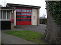
Sandy fire station
The fire station is right next to our school (St Swithun's).
This picture was taken on a geography field trip discovering land use with St Swithun's V.C. Lower School.
This land is used for business but mainly housing.
Image: © St Swithun's VC Lower School
Taken: 15 Mar 2007
0.08 miles
6
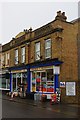
Gilby?s of Sandy
Gilby’s is a hardware store and ironmonger in Sandy. Next door is a hairdresser with an easily-misread name.
Image: © Ben Harris
Taken: 18 Feb 2012
0.09 miles
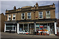
7
Gilby's of Sandy, 55 High Street
Hardware and ironmongers shop.
Image: © N Avery
Taken: 23 May 2006
0.10 miles
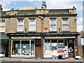
8
Gilbeys of Sandy
In the centre of the roof, it is possible to make out lettering that presumably referred to an earlier use of this building, although it is too indistinct to be read.
Any information as to what this "ghost sign" may be would be gratefully received.
Image: © Robert Eva
Taken: 8 Jun 2018
0.10 miles
9
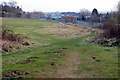
The Greensand Ridge Walk crosses the recreation ground
Image: © Philip Jeffrey
Taken: 17 Mar 2016
0.10 miles
10
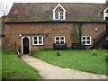
Rectory
This is for the church which is near our school.
This picture was taken on a geography field trip with St Swithun's V.C. Lower School. We discovered land use in our local area.
This area is mainly religious land use with some housing and business.
Image: © St Swithun's VC Lower School
Taken: 15 Mar 2007
0.11 miles