IMAGES TAKEN NEAR TO
Serpentine Close, STEVENAGE, SG1 6AR
Introduction
This page details the photographs taken nearby to Serpentine Close, SG1 6AR by members of the Geograph project.
The Geograph project started in 2005 with the aim of publishing, organising and preserving representative images for every square kilometre of Great Britain, Ireland and the Isle of Man.

There are currently over 7.5m images from over14,400 individuals and you can help contribute to the project by visiting https://www.geograph.org.uk
Image Map
Images are licensed for reuse under creativecommons.org/licenses/by-sa/2.0
Notes
- Clicking on the map will re-center to the selected point.
- The higher the marker number, the further away the image location is from the centre of the postcode.
Image Listing (3 Images Found)
Images are licensed for reuse under creativecommons.org/licenses/by-sa/2.0
Image
Details
Distance
1
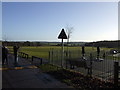
Play area and recreation ground
Play area and recreation ground created after the construction of the housing at Great Ashby below Clayhills Springs
Image: © Graham Burnett
Taken: 1 Jan 2007
0.05 miles
2
Pin Green Industrial Estate, Great Ashby
Industrial estate surrounded by housing in north Stevenage.
Image: © M J Richardson
Taken: 20 Sep 2017
0.20 miles
3

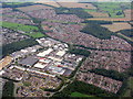
Stevenage from the air
Pin Green industrial estate is prominent.
Image: © Thomas Nugent
Taken: 17 Jul 2024
0.25 miles