IMAGES TAKEN NEAR TO
Old Bourne Way, STEVENAGE, SG1 6AD
Introduction
This page details the photographs taken nearby to Old Bourne Way, SG1 6AD by members of the Geograph project.
The Geograph project started in 2005 with the aim of publishing, organising and preserving representative images for every square kilometre of Great Britain, Ireland and the Isle of Man.

There are currently over 7.5m images from over14,400 individuals and you can help contribute to the project by visiting https://www.geograph.org.uk
Image Map
Images are licensed for reuse under creativecommons.org/licenses/by-sa/2.0
Notes
- Clicking on the map will re-center to the selected point.
- The higher the marker number, the further away the image location is from the centre of the postcode.
Image Listing (6 Images Found)
Images are licensed for reuse under creativecommons.org/licenses/by-sa/2.0
Image
Details
Distance
1
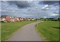
The green, Great Ashby, Stevenage
This grass strip seems to owe its existence to the two parallel overhead power lines.
Image: © Humphrey Bolton
Taken: 19 Sep 2012
0.11 miles
2
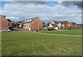
Swale Close at the green, Great Ashby, Stevenage
Image: © Humphrey Bolton
Taken: 19 Sep 2012
0.12 miles
3

The end of the green strip, Great Ashby, Stevenage
Although the housing development continues on each side, beyond Botany Bay Lane, which runs diagonally across, marked by the line of trees, the strip between the power lines is fields, not public open space.
Image: © Humphrey Bolton
Taken: 19 Sep 2012
0.19 miles

5
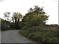
Back Lane, Stevenage
The very fringe of Stevenage adjacent to open farmland
Image: © David Howard
Taken: 5 Oct 2017
0.22 miles
6
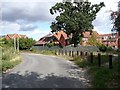
The junction of Botany Bay Lane and Back Lane
Botany Bay Lane led to a farm called Botany Bay, demolished for the housing estate. Beyond it the lane continues as a bridleway.
Image: © Humphrey Bolton
Taken: 19 Sep 2012
0.23 miles