IMAGES TAKEN NEAR TO
Meppershall Road, HENLOW, SG16 6LJ
Introduction
This page details the photographs taken nearby to Meppershall Road, SG16 6LJ by members of the Geograph project.
The Geograph project started in 2005 with the aim of publishing, organising and preserving representative images for every square kilometre of Great Britain, Ireland and the Isle of Man.

There are currently over 7.5m images from over14,400 individuals and you can help contribute to the project by visiting https://www.geograph.org.uk
Image Map
Images are licensed for reuse under creativecommons.org/licenses/by-sa/2.0
Notes
- Clicking on the map will re-center to the selected point.
- The higher the marker number, the further away the image location is from the centre of the postcode.
Image Listing (9 Images Found)
Images are licensed for reuse under creativecommons.org/licenses/by-sa/2.0
Image
Details
Distance
1
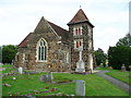
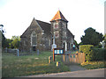
All Saints Church, Stondon
Built of ironstone in 1857 to replace a church of the 12C to 13C. Listed Grade II. The south doorway is 13C, re-used, and the font is also probably 13C.
Image: © Humphrey Bolton
Taken: 12 Jul 2014
0.04 miles
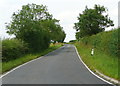
3
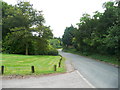
Meppershall Road, Upper Stondon
There is a curving country lane between Lower and Upper Stondon.
Image: © Humphrey Bolton
Taken: 12 Jul 2014
0.04 miles
4
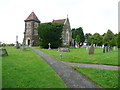
All Saints' church, Upper Stondon, Beds
re-erected in 1857, chiefly by subscription of the landed proprietors of the parish and the adjoining hamlet of Lower Stondon, and is a building of sandstone in the Decorated style. http://www.genuki.org.uk/big/eng/BDF/UpperStondon/index.html
Image: © Rodney Burton
Taken: 28 Jun 2006
0.04 miles
5

Bends on Meppershall Road, Upper Stondon
Image: © David Howard
Taken: 16 Jan 2022
0.08 miles
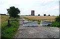
6
Barrier on field access track, Upper Stondon
This looks like a driveway to a house, perhaps Rectory Farm, with the mown lawn and row of trees, but could just be a field access track, not in use at present.
Image: © Humphrey Bolton
Taken: 12 Jul 2014
0.15 miles
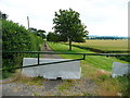
8
Barrier on field access track, Upper Stondon
This wide track looks like a lane, but seems always to have been just an access track. Presumably it is no longer in regular use.
Image: © Humphrey Bolton
Taken: 12 Jul 2014
0.16 miles
9

View from Meppershall Road, Upper Stondon
Image: © David Howard
Taken: 16 Jan 2022
0.17 miles