IMAGES TAKEN NEAR TO
High Street, ARLESEY, SG15 6RA
Introduction
This page details the photographs taken nearby to High Street, SG15 6RA by members of the Geograph project.
The Geograph project started in 2005 with the aim of publishing, organising and preserving representative images for every square kilometre of Great Britain, Ireland and the Isle of Man.

There are currently over 7.5m images from over14,400 individuals and you can help contribute to the project by visiting https://www.geograph.org.uk
Image Map
Images are licensed for reuse under creativecommons.org/licenses/by-sa/2.0
Notes
- Clicking on the map will re-center to the selected point.
- The higher the marker number, the further away the image location is from the centre of the postcode.
Image Listing (23 Images Found)
Images are licensed for reuse under creativecommons.org/licenses/by-sa/2.0
Image
Details
Distance

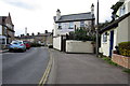
2
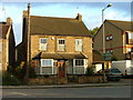
The house that we might have bought.
For a variety of reasons we didn't. This is typical of the houses in Arlesey. Note the light coloured brick. This is made from clay dug locally and turned into bricks by a (largely) italian immigrant workforce near to the village.
Image: © Robin Hall
Taken: 30 Oct 2005
0.05 miles
3
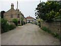
Davis Row
Just one motor vehicle on a normally busy mud track. Previously known as Paradise Row. The home in the foreground to the left was The Stag Public House which opened in 1868 and closed in 1926.
Image: © Malcolm Campbell
Taken: 5 Jul 2006
0.05 miles
4
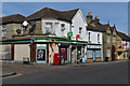
Convenience store on corner of Hospital Road, Arlesey
Image: © David Martin
Taken: 12 Sep 2020
0.06 miles
5
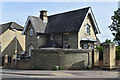
Former lodge at entrance to Fairfield Hospital
The site closed as a hospital in 1999.
Image: © David Martin
Taken: 12 Sep 2020
0.06 miles
6

Arlesey: High Street garage
Small independent fuel retailers find it difficult to compete against the oil giants and the supermarkets and the small garage here has lost its forecourt dispensing pumps some time ago.
Image: © Nigel Cox
Taken: 13 Jun 2010
0.07 miles
8
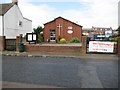
Arlesey Methodist Church
The Church is on the west side of the High Street and was opened in 1981 at a cost of £85,000.
Image: © Nigel Cox
Taken: 13 Jun 2010
0.10 miles
9
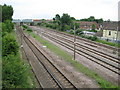
Arlesey: Site of the former Three Counties railway station
The Great Northern Railway was completed through here in 1850 and a station, called Arlesey Siding and named because of the sidings to the nearby brick works, was built here in 1866. With the expansion of the nearby Three Counties Lunatic Asylum the station was renamed Three Counties in 1886. It closed in 1959. Looking at old maps the actual site of the station was about two thirds of the way towards the distant Mill Lane road bridge. This was the site of a fatal railway accident in 1876 when a northbound express passenger train collided with a derailed luggage train.
Image: © Nigel Cox
Taken: 13 Jun 2010
0.14 miles
10
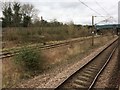
View from a Peterborough-London train - Site of Three Counties station
Opened in 1866 by the Great Northern Railway, the station closed to passengers in 1959.
For the first 20 years of its existence, it was called 'Arlesey Siding'. Presumably the Victorian marketing people eventually decided that didn't sound very attractive!
Image: © Nigel Thompson
Taken: 18 Mar 2017
0.14 miles