IMAGES TAKEN NEAR TO
Mathews Close, STEVENAGE, SG1 4XB
Introduction
This page details the photographs taken nearby to Mathews Close, SG1 4XB by members of the Geograph project.
The Geograph project started in 2005 with the aim of publishing, organising and preserving representative images for every square kilometre of Great Britain, Ireland and the Isle of Man.

There are currently over 7.5m images from over14,400 individuals and you can help contribute to the project by visiting https://www.geograph.org.uk
Image Map
Images are licensed for reuse under creativecommons.org/licenses/by-sa/2.0
Notes
- Clicking on the map will re-center to the selected point.
- The higher the marker number, the further away the image location is from the centre of the postcode.
Image Listing (33 Images Found)
Images are licensed for reuse under creativecommons.org/licenses/by-sa/2.0
Image
Details
Distance
1
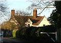
The Bury.
There are prominent "Private" signs. The best photo seems to be "over the hedge".
Image: © Robin Hall
Taken: 20 Jan 2006
0.12 miles
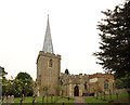
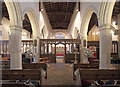
3
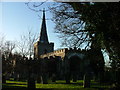
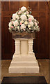
St Nicholas' Church, Stevenage
At the rear of the church yard there is a memorial to EM Forster.
Image: © Robin Hall
Taken: 20 Jan 2005
0.16 miles
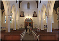
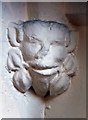
10
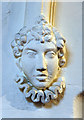
St Nicholas, Old Stevenage - Label head
Image: © John Salmon
Taken: 17 Sep 2016
0.18 miles