IMAGES TAKEN NEAR TO
Coreys Mill Lane, STEVENAGE, SG1 4RT
Introduction
This page details the photographs taken nearby to Coreys Mill Lane, SG1 4RT by members of the Geograph project.
The Geograph project started in 2005 with the aim of publishing, organising and preserving representative images for every square kilometre of Great Britain, Ireland and the Isle of Man.

There are currently over 7.5m images from over14,400 individuals and you can help contribute to the project by visiting https://www.geograph.org.uk
Image Map
Images are licensed for reuse under creativecommons.org/licenses/by-sa/2.0
Notes
- Clicking on the map will re-center to the selected point.
- The higher the marker number, the further away the image location is from the centre of the postcode.
Image Listing (9 Images Found)
Images are licensed for reuse under creativecommons.org/licenses/by-sa/2.0
Image
Details
Distance
1
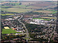
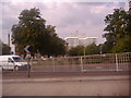
Whitney Wood and Lister Hospital, Stevenage
Looking north from above the town centre. The A602 runs up to the A1(M) at J8.
Image: © M J Richardson
Taken: 20 Sep 2017
0.15 miles
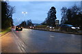
3
The Lister Hospital, Stevenage
From Hitchin Road
Image: © David Howard
Taken: 3 Aug 2011
0.18 miles
4
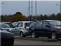
Lister Hospital Car Park
Patients and visitors car park, situated on the north side of the hospital. Does not yet appear to be marked on the map.
Image: © Dennis simpson
Taken: 12 Nov 2010
0.18 miles
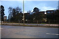
7

How Many?
Miles to London that is. Mile marker at the side of the road.
Image: © Dennis simpson
Taken: 12 Nov 2010
0.23 miles