IMAGES TAKEN NEAR TO
Rectory Lane, HERTFORD, SG14 3SG
Introduction
This page details the photographs taken nearby to Rectory Lane, SG14 3SG by members of the Geograph project.
The Geograph project started in 2005 with the aim of publishing, organising and preserving representative images for every square kilometre of Great Britain, Ireland and the Isle of Man.

There are currently over 7.5m images from over14,400 individuals and you can help contribute to the project by visiting https://www.geograph.org.uk
Image Map (Loading...)


Getting Data...Please wait
Leaflet Map data © OpenStreetMap
Images are licensed for reuse under creativecommons.org/licenses/by-sa/2.0
Notes
- Clicking on the map will re-center to the selected point.
- The higher the marker number, the further away the image location is from the centre of the postcode.
Image Listing (76 Images Found)
Images are licensed for reuse under creativecommons.org/licenses/by-sa/2.0
Image
Details
Distance
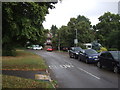
2
Footpath alongside Station Road, Watton at Stone
Providing a slightly more direct route for pedestrians.
Image: © Richard Vince
Taken: 14 Jan 2023
0.10 miles
4
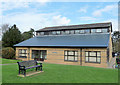
Nigel Poulton Community Hall, Watton at Stone
Community Hall with sports hall changing room and Pavilion built in 1996.
Image: © Vernon Dunhill
Taken: 16 Apr 2016
0.10 miles

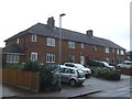
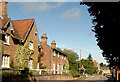
6

Houses on Station Road, Watton at Stone
Image: © David Howard
Taken: 25 Jun 2015
0.10 miles
8
Playing field and tennis courts at Watton at Stone
Image: © Philip Jeffrey
Taken: 2 Oct 2022
0.12 miles
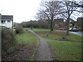
10
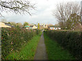
Footpath between the village centre and the church, Watton at Stone
Image: © Humphrey Bolton
Taken: 13 Jan 2020
0.14 miles