IMAGES TAKEN NEAR TO
Glebe Road, HERTFORD, SG14 3JY
Introduction
This page details the photographs taken nearby to Glebe Road, SG14 3JY by members of the Geograph project.
The Geograph project started in 2005 with the aim of publishing, organising and preserving representative images for every square kilometre of Great Britain, Ireland and the Isle of Man.

There are currently over 7.5m images from over14,400 individuals and you can help contribute to the project by visiting https://www.geograph.org.uk
Image Map
Images are licensed for reuse under creativecommons.org/licenses/by-sa/2.0
Notes
- Clicking on the map will re-center to the selected point.
- The higher the marker number, the further away the image location is from the centre of the postcode.
Image Listing (37 Images Found)
Images are licensed for reuse under creativecommons.org/licenses/by-sa/2.0
Image
Details
Distance
1
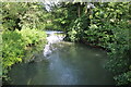
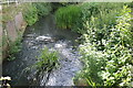
River Rib in Bengeo
The River Rib is a tributary of the River Lee and is pictured here looking upstream from the Ware Park Road bridge and about 500 metres upstream of its confluence with the Lee.
Image: © Nigel Cox
Taken: 25 Nov 2007
0.12 miles
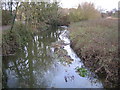
4
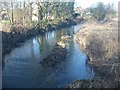
River Rib above Ware Park Road bridge, Bengeo
Image: © David Leeming
Taken: 9 Jan 2013
0.18 miles
7
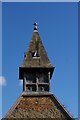
Tower, St Leonard's Church, Bengeo, Hertfordshire
Norman village church
Image: © Jim Osley
Taken: 2 Mar 2007
0.20 miles
8
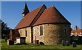
St Leonard's Church, Bengeo, Hertfordshire
Norman village church
Image: © Jim Osley
Taken: 2 Mar 2007
0.20 miles