IMAGES TAKEN NEAR TO
Woodland Grove, SG14 3FQ
Introduction
This page details the photographs taken nearby to Woodland Grove, SG14 3FQ by members of the Geograph project.
The Geograph project started in 2005 with the aim of publishing, organising and preserving representative images for every square kilometre of Great Britain, Ireland and the Isle of Man.

There are currently over 7.5m images from over14,400 individuals and you can help contribute to the project by visiting https://www.geograph.org.uk
Image Map (Loading...)


Getting Data...Please wait
Leaflet Map data © OpenStreetMap
Images are licensed for reuse under creativecommons.org/licenses/by-sa/2.0
Notes
- Clicking on the map will re-center to the selected point.
- The higher the marker number, the further away the image location is from the centre of the postcode.
Image Listing (14 Images Found)
Images are licensed for reuse under creativecommons.org/licenses/by-sa/2.0
Image
Details
Distance
1
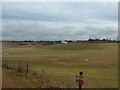
Bengeo Gravel Pits
Gravel pits, looking from Sacombe Road towards Chapmore End
Image: © Melvyn Cousins
Taken: 9 Mar 2006
0.04 miles
2
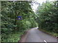
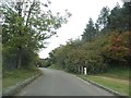
Weak bridge ahead on Vicarage Lane
Towards Waterford.
Image: © JThomas
Taken: 27 Jul 2019
0.09 miles
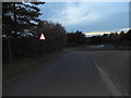
8
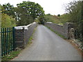
Waterford: Vicarage Lane railway bridge
This narrow bridge carries Vicarage Lane over the Hertford Loop railway line.
Image: © Nigel Cox
Taken: 29 Sep 2009
0.16 miles
9
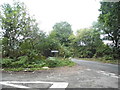
Bullsmill Lane at the junction of Sacombe Road
Image: © David Howard
Taken: 17 Sep 2015
0.17 miles
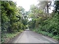
10
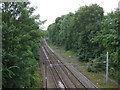
Railway towards London
View from the bridge on Vicarage Lane.
Image: © JThomas
Taken: 27 Jul 2019
0.18 miles