IMAGES TAKEN NEAR TO
Cumberland Close, HERTFORD, SG14 3EF
Introduction
This page details the photographs taken nearby to Cumberland Close, SG14 3EF by members of the Geograph project.
The Geograph project started in 2005 with the aim of publishing, organising and preserving representative images for every square kilometre of Great Britain, Ireland and the Isle of Man.

There are currently over 7.5m images from over14,400 individuals and you can help contribute to the project by visiting https://www.geograph.org.uk
Image Map
Images are licensed for reuse under creativecommons.org/licenses/by-sa/2.0
Notes
- Clicking on the map will re-center to the selected point.
- The higher the marker number, the further away the image location is from the centre of the postcode.
Image Listing (9 Images Found)
Images are licensed for reuse under creativecommons.org/licenses/by-sa/2.0
Image
Details
Distance
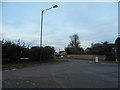
4
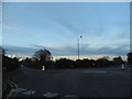
Mini roundabout on Bengeo Street
Sacombe Road is on the left, Wadesmill Road on the right. Bengeo means crossing over the river Beane.
Image: © David Howard
Taken: 3 Nov 2012
0.23 miles
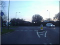
5
Looking towards Wadesmill Road from the roundabout on Bengeo Street
Sacombe Road is on the left
Image: © David Howard
Taken: 3 Nov 2012
0.23 miles
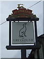
6
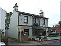
The Greyhound, Bengeo, Hertford
On Bengeo Street.
Image: © JThomas
Taken: 27 Jul 2019
0.24 miles
7
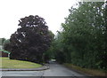
Junction of Wadesmill Road and Sacombe Road, Bengeo
Image: © David Howard
Taken: 6 Mar 2012
0.24 miles
9
Sacombe Road, Hertford
Junction with The Wick.
Image: © JThomas
Taken: 27 Jul 2019
0.25 miles