IMAGES TAKEN NEAR TO
Hooks Cross, HERTFORD, SG14 2RL
Introduction
This page details the photographs taken nearby to Hooks Cross, SG14 2RL by members of the Geograph project.
The Geograph project started in 2005 with the aim of publishing, organising and preserving representative images for every square kilometre of Great Britain, Ireland and the Isle of Man.

There are currently over 7.5m images from over14,400 individuals and you can help contribute to the project by visiting https://www.geograph.org.uk
Image Map (Loading...)


Getting Data...Please wait
Leaflet Map data © OpenStreetMap
Images are licensed for reuse under creativecommons.org/licenses/by-sa/2.0
Notes
- Clicking on the map will re-center to the selected point.
- The higher the marker number, the further away the image location is from the centre of the postcode.
Image Listing (3 Images Found)
Images are licensed for reuse under creativecommons.org/licenses/by-sa/2.0
Image
Details
Distance
1
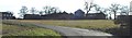
Hazel Farm
Photographed into the sun I'm afraid.
Image: © Robin Hall
Taken: 10 Feb 2006
0.05 miles
2
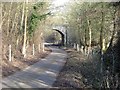
Raffin Lane passes under the Hertford loop of the Stevenage - London railway.
Hale's Wood on the left.
Image: © Robin Hall
Taken: 10 Feb 2006
0.11 miles
3
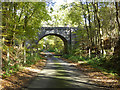
Railway bridge over Raffin Green Lane
The Hertford Loop line (HDB) crosses.
Image: © Robin Webster
Taken: 5 Nov 2017
0.14 miles