IMAGES TAKEN NEAR TO
The Ridgeway, HERTFORD, SG14 2JU
Introduction
This page details the photographs taken nearby to The Ridgeway, SG14 2JU by members of the Geograph project.
The Geograph project started in 2005 with the aim of publishing, organising and preserving representative images for every square kilometre of Great Britain, Ireland and the Isle of Man.

There are currently over 7.5m images from over14,400 individuals and you can help contribute to the project by visiting https://www.geograph.org.uk
Image Map
Images are licensed for reuse under creativecommons.org/licenses/by-sa/2.0
Notes
- Clicking on the map will re-center to the selected point.
- The higher the marker number, the further away the image location is from the centre of the postcode.
Image Listing (13 Images Found)
Images are licensed for reuse under creativecommons.org/licenses/by-sa/2.0
Image
Details
Distance
1
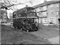
Bentley Road terminus
A vintage bus at the terminus of the 310 and 395 routes to Sele Farm Estate. RT3028 (LYF 21) is operating as part of a vintage bus festival. Efforts were made to exclude modern features of the scene, but parked cars are now ubiquitous, whereas at the time these buses were in use, private cars were fewer and satellite TV quite unknown.
The monochrome was forced upon me by an erroneous camera setting, but is appropriate and an homage to Image, showing changed operating practices on these routes.
Image: © Jonathan Wilkins
Taken: 7 Apr 2024
0.09 miles
2
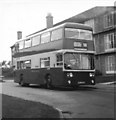
Sele Farm, Bentley Road
London Country AN113 (MPJ213L) a Leyland Atlantean PDR1A/1 with a 72 seater dual doorway Metro-Cammell body at the Sele Farm terminus of route 310 in brand new condition. A few weeks after this photo was taken the vehicle was transferred from Hertford Garage to Grays Garage.
The destination display reads "Hertford Road, Bullsmoor Lane", which is one that was only infrequently used.
Image: © Rob Candlish
Taken: Unknown
0.11 miles
3
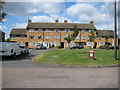
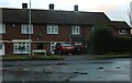
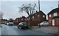
Hertford: Sele Farm estate
Sele Farm estate is a large post-war housing development on the north-west side of Hertford. The photo shows a typical block of housing, this one being in Edmunds Road. The original Sele Farm was at the back of North Road Avenue.
Image: © Nigel Cox
Taken: 22 May 2009
0.13 miles
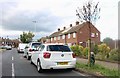
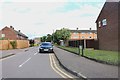
5
Bentley Road, Hertford
From the end of Calton Avenue
Image: © David Howard
Taken: 12 Dec 2021
0.15 miles
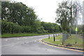
6
Lawrence Road, Hertford
This is the beginning of Hertford from the west side.
Image: © David Howard
Taken: 1 Jul 2019
0.16 miles
7
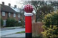
Knitted letterbox cover on Bentley Road, Hertford
There is a local workshop making these who have just been on the TV
Image: © David Howard
Taken: 12 Dec 2021
0.16 miles
8
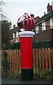
Knitted letterbox cover on Bentley Road, Hertford
There is a local workshop making these who have just been on the TV
Image: © David Howard
Taken: 12 Dec 2021
0.17 miles
10
Bentley Road at the junction of Panshanger Road
Image: © David Howard
Taken: 1 Jul 2019
0.21 miles