IMAGES TAKEN NEAR TO
Cowbridge, HERTFORD, SG14 1QY
Introduction
This page details the photographs taken nearby to Cowbridge, SG14 1QY by members of the Geograph project.
The Geograph project started in 2005 with the aim of publishing, organising and preserving representative images for every square kilometre of Great Britain, Ireland and the Isle of Man.

There are currently over 7.5m images from over14,400 individuals and you can help contribute to the project by visiting https://www.geograph.org.uk
Image Map
Images are licensed for reuse under creativecommons.org/licenses/by-sa/2.0
Notes
- Clicking on the map will re-center to the selected point.
- The higher the marker number, the further away the image location is from the centre of the postcode.
Image Listing (330 Images Found)
Images are licensed for reuse under creativecommons.org/licenses/by-sa/2.0
Image
Details
Distance
1
Cowbridge, Hertford
The road crosses the bridge over the river by the red car half way along.
Image: © David Howard
Taken: 7 Feb 2009
0.02 miles
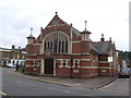
2
Hertford Town Church
Background information at this http://www.hertfordtownchurch.org/history.htm.
Image: © Jim Osley
Taken: 28 Dec 2013
0.02 miles
3
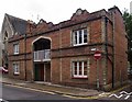
Prince Albert Cottages, Cowbridge, Hertford
At first sight I thought these might be almshouses - though almshouses are more often single-storey, with gardens. The Hertfordshire volume of 'The Buildings of England' (Pevsner, revised by Cherry) confirms that these were philanthropic dwellings, but with a particularly interesting history: 'On the left [in Cowbridge] is a neo-Jacobean cottage with a middle loggia. This is a replica of one designed by H.Roberts for the 1851 Exhibition as an example of the improved working-class housing developed at the request of Prince Albert'.
The name 'Prince Albert Cottages' I was able to glean from the Google map.
Image: © Stefan Czapski
Taken: 23 Jun 2013
0.02 miles
4
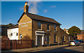
Ekins & Co
A building contractor's offices on Hartham Road, just across from the old brewery Image
Image: © Stephen Craven
Taken: 4 Jun 2011
0.03 miles
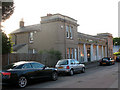
5
Prince Albert model cottages, Hertford
For the Great Exhibition of 1851 the architect Henry Roberts design a pair of model cottages. These were eventually re-located to Kennington. The design was replicated at Hertford. More at this https://en.wikipedia.org/wiki/List_of_existing_model_dwellings. For the Kennington cottages see this http://www.geograph.org.uk/photo/3817716.
Image: © Jim Osley
Taken: 11 Aug 2016
0.04 miles
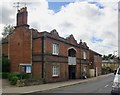
6
Hertford Town Church
An independent church in Hartham Lane.
McMullens brewery premises occupy the rest of the street.
The Church website has a photo of the old building on this site. http://www.hertfordtownchurch.org/history2.htm
Image: © Des Blenkinsopp
Taken: 17 Sep 2010
0.04 miles
7
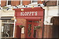
Sloppy's, Old Cross
This rather unglamorously named bar is the location of the original Sugar Hut nightclub, made famous by The Only Way Is Essex, before it moved to its more well-known location, Brentwood. Looking west-southwest.
Image: © Robert Lamb
Taken: 3 May 2015
0.04 miles
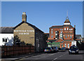
9
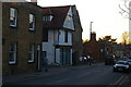
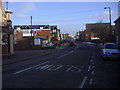
Hertford: looking north up Cowbridge
Image: © Christopher Hilton
Taken: 26 Feb 2019
0.05 miles
10
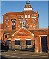
Hertford Brewery (built 1891)
Grade II listed building, extensively described at this http://list.english-heritage.org.uk/resultsingle.aspx?uid=1268883.
Image: © Jim Osley
Taken: 28 Dec 2013
0.05 miles