IMAGES TAKEN NEAR TO
Havelock Gardens, HERTFORD, SG14 1FH
Introduction
This page details the photographs taken nearby to Havelock Gardens, SG14 1FH by members of the Geograph project.
The Geograph project started in 2005 with the aim of publishing, organising and preserving representative images for every square kilometre of Great Britain, Ireland and the Isle of Man.

There are currently over 7.5m images from over14,400 individuals and you can help contribute to the project by visiting https://www.geograph.org.uk
Image Map (Loading...)


Getting Data...Please wait
Leaflet Map data © OpenStreetMap
Images are licensed for reuse under creativecommons.org/licenses/by-sa/2.0
Notes
- Clicking on the map will re-center to the selected point.
- The higher the marker number, the further away the image location is from the centre of the postcode.
Image Listing (263 Images Found)
Images are licensed for reuse under creativecommons.org/licenses/by-sa/2.0
Image
Details
Distance
1
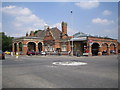
Hertford East railway station
The station was built around 1886 and replaced an earlier station at the north end of Railway Place several hundred metres to the east.
Image: © Nigel Cox
Taken: 21 Jul 2006
0.03 miles
2
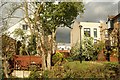
View of the rear of houses on Priory Drive from the Lea towpath
Looking south-southeast.
Image: © Robert Lamb
Taken: 3 May 2015
0.05 miles
3
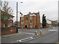
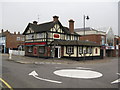
The 'Dolphin', Hertford
Opposite Hertford East station, this Victorian pub is sadly closed at present. Not surprisingly, it was formerly called the 'Station Hotel'. All it needs is someone with a bit of flair and a bit of money, and with real ale, jazz twice a week, and accommodation available, this could once again be the place to go in Hertford. Yes, and restore its original, meaningful, name.
Image: © Dr Neil Clifton
Taken: 19 Oct 2009
0.05 miles
4
View of the rear of houses on the River Lea from the Lea towpath #3
Looking north-northeast.
Image: © Robert Lamb
Taken: 3 May 2015
0.05 miles
5
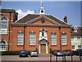
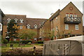
Hertford: The former Christ's Hospital
The building at the north end of Bluecoats Avenue.
Image: © Nigel Cox
Taken: 21 Jul 2006
0.05 miles
7
View of the rear of houses on the River Lea from the Lea towpath #4
Looking south-southeast.
Image: © Robert Lamb
Taken: 3 May 2015
0.06 miles
8
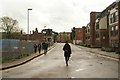
View down Mill Road towards Hertford East station
Looking south-southeast.
Image: © Robert Lamb
Taken: 3 May 2015
0.06 miles
9
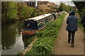
View of narrowboats moored on the River Lea
Looking south-southwest.
Image: © Robert Lamb
Taken: 3 May 2015
0.07 miles
10
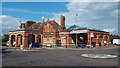
Hertford East railway station
Hertford East railway station is at the end of a branch line from Broxbourne. Trains from here generally run to London's Liverpool Street terminus.
The station building dates from the 1880s. It is a short distance to the east of Hertford's historic town centre.
Image: © Malc McDonald
Taken: 3 Aug 2013
0.07 miles