IMAGES TAKEN NEAR TO
Lower Hatfield Road, HERTFORD, SG13 8XX
Introduction
This page details the photographs taken nearby to Lower Hatfield Road, SG13 8XX by members of the Geograph project.
The Geograph project started in 2005 with the aim of publishing, organising and preserving representative images for every square kilometre of Great Britain, Ireland and the Isle of Man.

There are currently over 7.5m images from over14,400 individuals and you can help contribute to the project by visiting https://www.geograph.org.uk
Image Map (Loading...)


Getting Data...Please wait
Leaflet Map data © OpenStreetMap
Images are licensed for reuse under creativecommons.org/licenses/by-sa/2.0
Notes
- Clicking on the map will re-center to the selected point.
- The higher the marker number, the further away the image location is from the centre of the postcode.
Image Listing (3 Images Found)
Images are licensed for reuse under creativecommons.org/licenses/by-sa/2.0
Image
Details
Distance
1
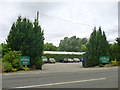
Entrance, Whistling Duck restaurant
Also a garden centre.
Image: © Robin Webster
Taken: 9 Jul 2016
0.01 miles
2

River Lea
Taken from the Riverside Garden Centre, which it flows behind.
Image: © Trevor Harris
Taken: 29 Mar 2014
0.03 miles
3
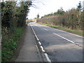
Hertford: B158 Lower Hatfield Road
Viewed from the railway viaduct looking towards Hatfield.
Image: © Nigel Cox
Taken: 3 Mar 2008
0.22 miles