IMAGES TAKEN NEAR TO
Fourways, HERTFORD, SG13 8PL
Introduction
This page details the photographs taken nearby to Fourways, SG13 8PL by members of the Geograph project.
The Geograph project started in 2005 with the aim of publishing, organising and preserving representative images for every square kilometre of Great Britain, Ireland and the Isle of Man.

There are currently over 7.5m images from over14,400 individuals and you can help contribute to the project by visiting https://www.geograph.org.uk
Image Map (Loading...)


Getting Data...Please wait
Leaflet Map data © OpenStreetMap
Images are licensed for reuse under creativecommons.org/licenses/by-sa/2.0
Notes
- Clicking on the map will re-center to the selected point.
- The higher the marker number, the further away the image location is from the centre of the postcode.
Image Listing (47 Images Found)
Images are licensed for reuse under creativecommons.org/licenses/by-sa/2.0
Image
Details
Distance
7

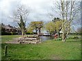
The Baker Arms, Bayford
Plainly not built as a pub - notice the domestic-looking front door at the near corner. Perhaps this was originally a terrace of estate cottages, but if so they were unusually substantial.
Image: © Stefan Czapski
Taken: 26 Jun 2014
0.04 miles
8
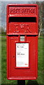
Close up, Elizabeth II postbox, Bayford
Postbox No. SG13 45.
See Image] for wider view.
Image: © JThomas
Taken: 23 Apr 2016
0.05 miles
9
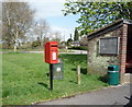
Elizabeth II postbox, Bayford
Postbox No. SG13 45.
See Image] for close up.
Image: © JThomas
Taken: 23 Apr 2016
0.05 miles