IMAGES TAKEN NEAR TO
Robins Nest Hill, HERTFORD, SG13 8LL
Introduction
This page details the photographs taken nearby to Robins Nest Hill, SG13 8LL by members of the Geograph project.
The Geograph project started in 2005 with the aim of publishing, organising and preserving representative images for every square kilometre of Great Britain, Ireland and the Isle of Man.

There are currently over 7.5m images from over14,400 individuals and you can help contribute to the project by visiting https://www.geograph.org.uk
Image Map (Loading...)


Getting Data...Please wait
Leaflet Map data © OpenStreetMap
Images are licensed for reuse under creativecommons.org/licenses/by-sa/2.0
Notes
- Clicking on the map will re-center to the selected point.
- The higher the marker number, the further away the image location is from the centre of the postcode.
Image Listing (2 Images Found)
Images are licensed for reuse under creativecommons.org/licenses/by-sa/2.0
Image
Details
Distance
1
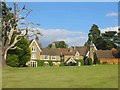
Culverwood House near Little Berkhamsted
The boundary hedge was just a little too tall to see via the viewfinder so the camera was held high.
Image: © Jack Hill
Taken: 7 Aug 2005
0.23 miles
2
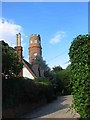
Strattons Folly from Bucks Alley, near Little Berkhamsted
The folly is indicated as tower on the old map
Image: © Jack Hill
Taken: 7 Aug 2005
0.23 miles