IMAGES TAKEN NEAR TO
Cecil Road, HERTFORD, SG13 8HS
Introduction
This page details the photographs taken nearby to Cecil Road, SG13 8HS by members of the Geograph project.
The Geograph project started in 2005 with the aim of publishing, organising and preserving representative images for every square kilometre of Great Britain, Ireland and the Isle of Man.

There are currently over 7.5m images from over14,400 individuals and you can help contribute to the project by visiting https://www.geograph.org.uk
Image Map
Images are licensed for reuse under creativecommons.org/licenses/by-sa/2.0
Notes
- Clicking on the map will re-center to the selected point.
- The higher the marker number, the further away the image location is from the centre of the postcode.
Image Listing (7 Images Found)
Images are licensed for reuse under creativecommons.org/licenses/by-sa/2.0
Image
Details
Distance
1
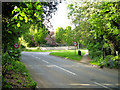
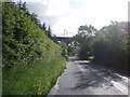
Brickendon Lane becomes suburban
The edge of the Hertford built-up area, with Mandeville Road on the right.
Image: © Robin Webster
Taken: 24 May 2016
0.12 miles
2
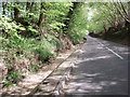
Brickendon Lane, Facing South
The channel beside the side of the road turns into a small river in wet weather during the winter.
Image: © Bikeboy
Taken: 13 May 2012
0.21 miles
3
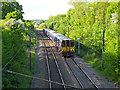
Up train on Hertford Loop line
A six car train headed by unit 313 050.
Image: © Robin Webster
Taken: 24 May 2016
0.22 miles
4
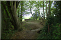
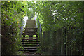
Footbridge on Hertfordshire Way
Leaving the wooded area on the edge of Hertford
Image: © Robert Eva
Taken: 14 Sep 2017
0.23 miles
5
Railway footbridge at the edge of Sailors Grove
Image: © Robert Eva
Taken: 14 Sep 2017
0.24 miles
6
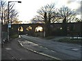
Railway Viaduct Over B158 at Hertford
See link for more geographs concerned with this railway line.
Image: © Bikeboy
Taken: 6 Jun 2012
0.24 miles
7
Viaduct where the railway line passes over the Hatfield Road, Hertford
Image: © Christine Matthews
Taken: 29 Jan 2006
0.25 miles