IMAGES TAKEN NEAR TO
Elbow Lane, HERTFORD, SG13 7QA
Introduction
This page details the photographs taken nearby to Elbow Lane, SG13 7QA by members of the Geograph project.
The Geograph project started in 2005 with the aim of publishing, organising and preserving representative images for every square kilometre of Great Britain, Ireland and the Isle of Man.

There are currently over 7.5m images from over14,400 individuals and you can help contribute to the project by visiting https://www.geograph.org.uk
Image Map (Loading...)


Getting Data...Please wait
Leaflet Map data © OpenStreetMap
Images are licensed for reuse under creativecommons.org/licenses/by-sa/2.0
Notes
- Clicking on the map will re-center to the selected point.
- The higher the marker number, the further away the image location is from the centre of the postcode.
Image Listing (7 Images Found)
Images are licensed for reuse under creativecommons.org/licenses/by-sa/2.0
Image
Details
Distance
1
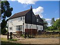
Elbow Lane Farm
Elbow Lane is the name given to this stretch of Ermine Street. The farmhouse stands just west of the old road.
Image: © Stefan Czapski
Taken: 6 Jul 2014
0.04 miles
2
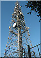
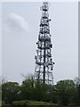
BT mast at Hertford Heath
A view from just outside the security fence, looking up at this mast which is situated adjacent to Elbow Lane.
Image: © Stephen Craven
Taken: 4 Jun 2011
0.15 miles
3
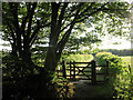
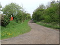
Diverted footpath
This footpath heading off to the west from Elbow Lane must have been diverted in recent years, because it now definitely starts at the southern, not the northern, end of the field where it is shown on OS maps at the time of submission. A kissing gate is provided.
Image: © Stephen Craven
Taken: 4 Jun 2011
0.15 miles
4
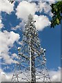
Radio mast by Elbow Lane
Standing very close to the ancient alignment of Ermine Street.
Image: © Stefan Czapski
Taken: 6 Jul 2014
0.15 miles
5
BT Radio mast on Ermine Street
This BT Radio mast is just to the east of the Roman Road Ermine Street.
Image: © Talisman
Taken: 3 May 2008
0.19 miles
6
Ermine Street at Elbow Lane Farm
Looking north along the Roman Road Ermine Street. The BT Radio Mast Image is just about visible in the top right of this photo.
What can you say about a Roman Road - it's straight.
Image: © Talisman
Taken: 3 May 2008
0.20 miles
7
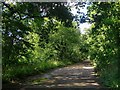
Ermine Street north of Elbow Lane Farm
Elbow Lane is the name by which Ermine Street is known locally. This stretch - from Elbow Lane Farm north towards Hertford Heath - has been made up as a rubble track, and has lost much of the ancient drove-road character that survives a little further south http://www.geograph.org.uk/photo/3355873
Image: © Stefan Czapski
Taken: 6 Jul 2014
0.21 miles