IMAGES TAKEN NEAR TO
The Roundings, HERTFORD, SG13 7PY
Introduction
This page details the photographs taken nearby to The Roundings, SG13 7PY by members of the Geograph project.
The Geograph project started in 2005 with the aim of publishing, organising and preserving representative images for every square kilometre of Great Britain, Ireland and the Isle of Man.

There are currently over 7.5m images from over14,400 individuals and you can help contribute to the project by visiting https://www.geograph.org.uk
Image Map (Loading...)


Getting Data...Please wait
Leaflet Map data © OpenStreetMap
Images are licensed for reuse under creativecommons.org/licenses/by-sa/2.0
Notes
- Clicking on the map will re-center to the selected point.
- The higher the marker number, the further away the image location is from the centre of the postcode.
Image Listing (4 Images Found)
Images are licensed for reuse under creativecommons.org/licenses/by-sa/2.0
Image
Details
Distance
1
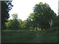
Clearing on Hertford Heath
This is a clearing in the woods just east of Elbow Lane. It is part of the Hertford Heath Nature Reserve.
Image: © Stephen Craven
Taken: 4 Jun 2011
0.12 miles
2
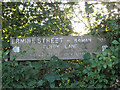
Ermine Street sign
A sign noting that this bridleway forms part of an old Roman road.
Image: © Stephen Craven
Taken: 4 Jun 2011
0.14 miles
3
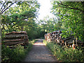
Log piles on Elbow Lane
Elbow Lane is a bridleway, and forms part of Ermine Street (old Roman road).
Image: © Stephen Craven
Taken: 4 Jun 2011
0.15 miles
4
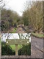
Ermine Street
This is The Old Roman Ermine Street, or the remains of it. It was built in the 1st Century A.D.to connect London to York, covering 200 miles.
Image: © Melvyn Cousins
Taken: 13 Mar 2006
0.18 miles