IMAGES TAKEN NEAR TO
Smeaton Court, HERTFORD, SG13 7AU
Introduction
This page details the photographs taken nearby to Smeaton Court, SG13 7AU by members of the Geograph project.
The Geograph project started in 2005 with the aim of publishing, organising and preserving representative images for every square kilometre of Great Britain, Ireland and the Isle of Man.

There are currently over 7.5m images from over14,400 individuals and you can help contribute to the project by visiting https://www.geograph.org.uk
Image Map (Loading...)


Getting Data...Please wait
Leaflet Map data © OpenStreetMap
Images are licensed for reuse under creativecommons.org/licenses/by-sa/2.0
Notes
- Clicking on the map will re-center to the selected point.
- The higher the marker number, the further away the image location is from the centre of the postcode.
Image Listing (119 Images Found)
Images are licensed for reuse under creativecommons.org/licenses/by-sa/2.0
Image
Details
Distance
1
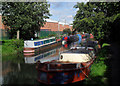
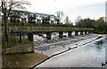
The Lea Navigation
A nondescript length between the scenic town centre and open country below Hertford Lock.
Image: © Des Blenkinsopp
Taken: 17 Sep 2010
0.04 miles
2
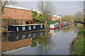
Lee Navigation, Hertford
Looking along the canal towards Hertford Lock.
Image: © Stephen McKay
Taken: 28 Mar 2011
0.09 miles
3
The River Lea Navigation north of Mead Lane, SG14
Image: © Mike Quinn
Taken: 23 Apr 2015
0.09 miles
4
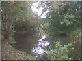
River Lee below Hartham Common
Above a weir, here the river is deeper and slow flowing in a shaded reach below the off-take of the Dicker Mill Stream and upstream of the confluence with the River Beane
Image: © David Leeming
Taken: 19 Oct 2012
0.11 miles
6
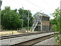
Old signal box, Hertford East
Hertford East signal box was made redundant when signalling for the branch line was centralised at Liverpool Street in London under the West Anglia Route Modernisation scheme (known by the acronym "WARM" to railwaymen).
Unlike the 1960s signal box at Ware (the next station down the line), which has now been demolished, Hertford East's box continues to stand derelict and unrepainted for years as something of an eyesore at this end of the town.
Image: © Rob Candlish
Taken: 26 Jul 2010
0.12 miles
7
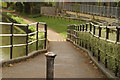
View up the riverside path from Mill Road
Looking north-northeast.
Image: © Robert Lamb
Taken: 3 May 2015
0.12 miles
8
Weirpool on the River Lee below Hartham Common
Image: © David Leeming
Taken: 19 Oct 2012
0.12 miles
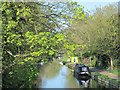
9
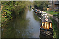
Lee Navigation, Hertford
Moored boats seen from Mill Road bridge.
Image: © Stephen McKay
Taken: 28 Mar 2011
0.12 miles
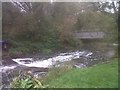
10
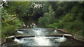
Weir on the River Lea, Hertford
A weir on the River Lea at Hertford.
Image: © Malc McDonald
Taken: 3 Aug 2013
0.13 miles