IMAGES TAKEN NEAR TO
Torquay Crescent, STEVENAGE, SG1 2RT
Introduction
This page details the photographs taken nearby to Torquay Crescent, SG1 2RT by members of the Geograph project.
The Geograph project started in 2005 with the aim of publishing, organising and preserving representative images for every square kilometre of Great Britain, Ireland and the Isle of Man.

There are currently over 7.5m images from over14,400 individuals and you can help contribute to the project by visiting https://www.geograph.org.uk
Image Map
Images are licensed for reuse under creativecommons.org/licenses/by-sa/2.0
Notes
- Clicking on the map will re-center to the selected point.
- The higher the marker number, the further away the image location is from the centre of the postcode.
Image Listing (6 Images Found)
Images are licensed for reuse under creativecommons.org/licenses/by-sa/2.0
Image
Details
Distance
1
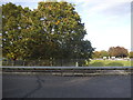
Roundabout on Gunnels Wood Road, Stevenage
Image: © David Howard
Taken: 28 Sep 2017
0.12 miles
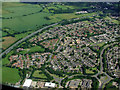
3
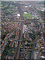
Stevenage from the air
A view of the railway station on approach to Luton Airport from the north east.
Image: © Thomas Nugent
Taken: 4 Nov 2011
0.17 miles
4
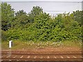
Trackside wild flowers
Waiting on the East Coast main line.
Image: © Steve Fareham
Taken: 18 Jun 2013
0.18 miles
5
Stevenage from the air
Symonds Green in the north west of Stevenage, bounded by the A1(M) motorway.
Image: © Thomas Nugent
Taken: 17 Jun 2012
0.20 miles
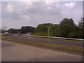
6
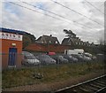
Waiting on an East Coast train outside Stevenage alongside J&B Autos
Image: © Steve Fareham
Taken: 28 Nov 2011
0.22 miles