IMAGES TAKEN NEAR TO
Fairview Road, STEVENAGE, SG1 2NS
Introduction
This page details the photographs taken nearby to Fairview Road, SG1 2NS by members of the Geograph project.
The Geograph project started in 2005 with the aim of publishing, organising and preserving representative images for every square kilometre of Great Britain, Ireland and the Isle of Man.

There are currently over 7.5m images from over14,400 individuals and you can help contribute to the project by visiting https://www.geograph.org.uk
Image Map
Images are licensed for reuse under creativecommons.org/licenses/by-sa/2.0
Notes
- Clicking on the map will re-center to the selected point.
- The higher the marker number, the further away the image location is from the centre of the postcode.
Image Listing (10 Images Found)
Images are licensed for reuse under creativecommons.org/licenses/by-sa/2.0
Image
Details
Distance
1
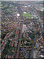
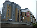
Stevenage from the air
A view of the railway station on approach to Luton Airport from the north east.
Image: © Thomas Nugent
Taken: 4 Nov 2011
0.11 miles
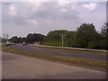
3
Roundabout on Gunnels Wood Road, Stevenage
Image: © David Howard
Taken: 28 Sep 2017
0.18 miles
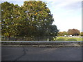
6
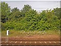
Trackside wild flowers
Waiting on the East Coast main line.
Image: © Steve Fareham
Taken: 18 Jun 2013
0.22 miles
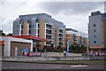
7
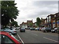
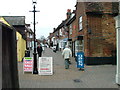
Stevenage Old Town
Old towns suffer from the motor car especially when nose in parking is the rule
Image: © Jack Hill
Taken: 4 Jul 2005
0.22 miles
8
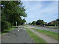
Cycle path beside Gunnels Wood Road (A1072)
Heading north.
Image: © JThomas
Taken: 15 Aug 2015
0.23 miles
9
Middle Row, Stevenage.
A 19th century pedestrian precinct? Shown on the OS map as a footpath.
Image: © Robin Hall
Taken: 19 Jan 2005
0.24 miles
10

Works entrance off Gunnels Wood Road (A1072)
Image: © JThomas
Taken: 15 Aug 2015
0.24 miles