IMAGES TAKEN NEAR TO
Hastings Close, STEVENAGE, SG1 2JG
Introduction
This page details the photographs taken nearby to Hastings Close, SG1 2JG by members of the Geograph project.
The Geograph project started in 2005 with the aim of publishing, organising and preserving representative images for every square kilometre of Great Britain, Ireland and the Isle of Man.

There are currently over 7.5m images from over14,400 individuals and you can help contribute to the project by visiting https://www.geograph.org.uk
Image Map
Images are licensed for reuse under creativecommons.org/licenses/by-sa/2.0
Notes
- Clicking on the map will re-center to the selected point.
- The higher the marker number, the further away the image location is from the centre of the postcode.
Image Listing (13 Images Found)
Images are licensed for reuse under creativecommons.org/licenses/by-sa/2.0
Image
Details
Distance
1
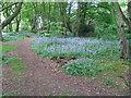
Bluebells in Lucas Wood North
View of Bluebells in wood by side of A1M at Symonds Green Area Of Stevenage. Old maps from 1700s show this area as "Lucas Wood"
Image: © John Taylor
Taken: 6 May 2006
0.09 miles
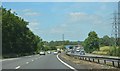
4
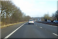
A1(M) northbound
Bypassing Stevenage which is to the right.
Image: © Robin Webster
Taken: 17 Feb 2018
0.11 miles
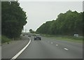
7
A1(M) northbound, north west of Stevenage
Image: © Colin Pyle
Taken: 3 Jul 2011
0.17 miles
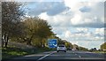
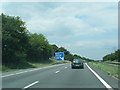
8
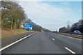
A1(M) northbound
1 mile to junction 8.
Image: © Robin Webster
Taken: 17 Feb 2018
0.17 miles
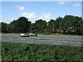
9
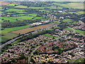
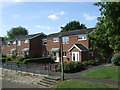
Fishers Green, Stevenage
The western boundary of the town, with the A1(M) running alongside.
Image: © M J Richardson
Taken: 20 Sep 2017
0.17 miles