IMAGES TAKEN NEAR TO
Scarborough Avenue, STEVENAGE, SG1 2HD
Introduction
This page details the photographs taken nearby to Scarborough Avenue, SG1 2HD by members of the Geograph project.
The Geograph project started in 2005 with the aim of publishing, organising and preserving representative images for every square kilometre of Great Britain, Ireland and the Isle of Man.

There are currently over 7.5m images from over14,400 individuals and you can help contribute to the project by visiting https://www.geograph.org.uk
Image Map
Images are licensed for reuse under creativecommons.org/licenses/by-sa/2.0
Notes
- Clicking on the map will re-center to the selected point.
- The higher the marker number, the further away the image location is from the centre of the postcode.
Image Listing (3 Images Found)
Images are licensed for reuse under creativecommons.org/licenses/by-sa/2.0
Image
Details
Distance
1

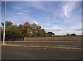
Scarborough Avenue playground.
Taken from Scarborough Avenue playground, in the distance, past the houses, the Lister Hospital (TL2226) can be seen.
Image: © Robin Hall
Taken: 25 Jul 2005
0.10 miles
2
Gunnels Wood Road, Stevenage
Crossing the railway line
Image: © David Howard
Taken: 28 Sep 2017
0.23 miles
3
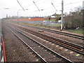
Stevenage railway station (site), Hertfordshire
Opened in 1850 by the Great Northern Railway on its line from London to Peterborough, this station survived until 1973 when it was replaced by a new one about a mile to the south, which is closer to the 'new' town. View north from passing train.
Image: © Nigel Thompson
Taken: 12 Feb 2011
0.25 miles