IMAGES TAKEN NEAR TO
Rutherford Close, STEVENAGE, SG1 2EF
Introduction
This page details the photographs taken nearby to Rutherford Close, SG1 2EF by members of the Geograph project.
The Geograph project started in 2005 with the aim of publishing, organising and preserving representative images for every square kilometre of Great Britain, Ireland and the Isle of Man.

There are currently over 7.5m images from over14,400 individuals and you can help contribute to the project by visiting https://www.geograph.org.uk
Image Map
Images are licensed for reuse under creativecommons.org/licenses/by-sa/2.0
Notes
- Clicking on the map will re-center to the selected point.
- The higher the marker number, the further away the image location is from the centre of the postcode.
Image Listing (9 Images Found)
Images are licensed for reuse under creativecommons.org/licenses/by-sa/2.0
Image
Details
Distance
1
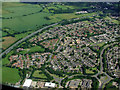
Stevenage from the air
Symonds Green in the north west of Stevenage, bounded by the A1(M) motorway.
Image: © Thomas Nugent
Taken: 17 Jun 2012
0.07 miles
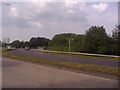
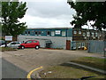
3
Roundabout on Gunnels Wood Road, Stevenage
Image: © David Howard
Taken: 28 Sep 2017
0.10 miles
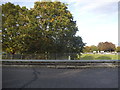
4

Works entrance off Gunnels Wood Road (A1072)
Image: © JThomas
Taken: 15 Aug 2015
0.14 miles
5
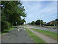
Cycle path beside Gunnels Wood Road (A1072)
Heading north.
Image: © JThomas
Taken: 15 Aug 2015
0.14 miles
6
Warehouse on Crompton Rd
This industrial estate consists of small units and this one could be any of them. A hundred yards behind me when I took this photograph is the A1(M), but you wouldn't know it from here and a couple of hundred yards further than that is an old Roman road.
Image: © Robin Hall
Taken: 25 Jul 2005
0.20 miles
7
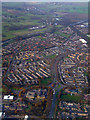
Stevenage from the air
Gunnels Wood Road at the roundabout at Clovelly Way as seen from a Luton bound flight from Prague.
Image: © Thomas Nugent
Taken: 18 Nov 2011
0.20 miles
8
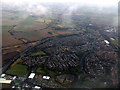
Stevenage from the air
Stevenage was the first land visible through the dense blanket of cloud that extended to the North Sea where the flight from Prague passed over Orford Ness.
The north east end of the town is visible here, with Meadway Playing Field to the lower left and the roundabout at Gunnels Wood Road and Bridge Road West in the lower right.
Image: © Thomas Nugent
Taken: 15 Mar 2013
0.20 miles
9

Portable toilets in Elliott Loohire depot
Image: © chris almond
Taken: 9 Oct 2008
0.20 miles