IMAGES TAKEN NEAR TO
Six Hills Way, STEVENAGE, SG1 2DA
Introduction
This page details the photographs taken nearby to Six Hills Way, SG1 2DA by members of the Geograph project.
The Geograph project started in 2005 with the aim of publishing, organising and preserving representative images for every square kilometre of Great Britain, Ireland and the Isle of Man.

There are currently over 7.5m images from over14,400 individuals and you can help contribute to the project by visiting https://www.geograph.org.uk
Image Map
Images are licensed for reuse under creativecommons.org/licenses/by-sa/2.0
Notes
- Clicking on the map will re-center to the selected point.
- The higher the marker number, the further away the image location is from the centre of the postcode.
Image Listing (22 Images Found)
Images are licensed for reuse under creativecommons.org/licenses/by-sa/2.0
Image
Details
Distance
1
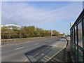
Gunnels Wood road, Stevenage
The A1072 looking north along the southbound carriageway.
Image: © Richard Rogerson
Taken: 22 Mar 2019
0.04 miles
4
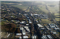
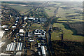
Stevenage from the air
The south west side of Stevenage, with Arlington Business Park and the Glaxo Smith Kline research campus visible between the A1(M) motorway and the East Coast Main Line railway. Knebworth can be seen in the distance. Stevenage Borough FC's ground Image can also be seen to the left of centre.
Image: © Thomas Nugent
Taken: 7 Feb 2014
0.14 miles
5
Stevenage from the air
The south west side of Stevenage, with Arlington Business Park and the Glaxo Smith Kline research campus visible between the A1(M) motorway and the East Coast Main Line railway. Knebworth can be seen in the distance.
Image: © Thomas Nugent
Taken: 7 Feb 2014
0.14 miles
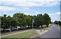
6
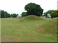
Six Hills
OK do you believe the OS who say that these features are tumuli or legend which says that these humps are lumps of soil thrown at travellers on the old Great North Road (just to the right of these humps but rather imposing nowadays)? It is said that these were thrown here from Weston Woods (Image and Image). Dick Turpin would have ridden past these on Black Bess on his ride from York to London.
Image: © Robin Hall
Taken: 25 Jul 2005
0.14 miles
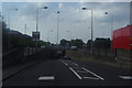
9
Western end of Six Hills Way
A main road leading out of Stevenage town centre.
Image: © Fernweh
Taken: 5 Aug 2013
0.16 miles
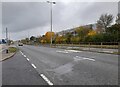
10
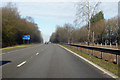
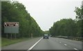
A1(M) northbound
At the 50 miles to Peterboro' (sic) sign.
Image: © Robin Webster
Taken: 17 Feb 2018
0.16 miles