IMAGES TAKEN NEAR TO
Leyden Road, STEVENAGE, SG1 2BP
Introduction
This page details the photographs taken nearby to Leyden Road, SG1 2BP by members of the Geograph project.
The Geograph project started in 2005 with the aim of publishing, organising and preserving representative images for every square kilometre of Great Britain, Ireland and the Isle of Man.

There are currently over 7.5m images from over14,400 individuals and you can help contribute to the project by visiting https://www.geograph.org.uk
Image Map
Images are licensed for reuse under creativecommons.org/licenses/by-sa/2.0
Notes
- Clicking on the map will re-center to the selected point.
- The higher the marker number, the further away the image location is from the centre of the postcode.
Image Listing (33 Images Found)
Images are licensed for reuse under creativecommons.org/licenses/by-sa/2.0
Image
Details
Distance
4
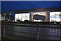
Sytner BMW on Gunnels Wood Road, Stevenage
Frank Sytner began his business in Nottingham and was also a fairly successful racing driver.
Image: © David Howard
Taken: 5 Dec 2022
0.08 miles
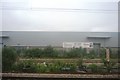
9
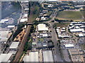
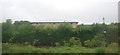
Gunnel's Wood Park
An aerial view of industrial estates at Stevenage. The railway is the East Coast Mainline; the branch off left goes to Hertford.
Image: © M J Richardson
Taken: 26 Jun 2015
0.13 miles
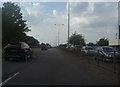
10
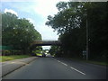
London Road south of Stevenage
The A602 is the bridge ahead.
Image: © David Howard
Taken: 3 Aug 2011
0.14 miles