IMAGES TAKEN NEAR TO
Farriers, WARE, SG12 9TL
Introduction
This page details the photographs taken nearby to Farriers, SG12 9TL by members of the Geograph project.
The Geograph project started in 2005 with the aim of publishing, organising and preserving representative images for every square kilometre of Great Britain, Ireland and the Isle of Man.

There are currently over 7.5m images from over14,400 individuals and you can help contribute to the project by visiting https://www.geograph.org.uk
Image Map (Loading...)


Getting Data...Please wait
Leaflet Map data © OpenStreetMap
Images are licensed for reuse under creativecommons.org/licenses/by-sa/2.0
Notes
- Clicking on the map will re-center to the selected point.
- The higher the marker number, the further away the image location is from the centre of the postcode.
Image Listing (57 Images Found)
Images are licensed for reuse under creativecommons.org/licenses/by-sa/2.0
Image
Details
Distance
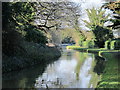
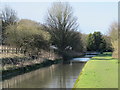
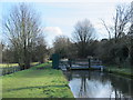
2
The New River between Lower Road and Amwell Hill, SG12 (2)
See Image
Image: © Mike Quinn
Taken: 14 Jan 2015
0.14 miles
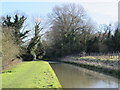
5
The New River between Lower Road and Amwell Hill, SG12
See Image
Image: © Mike Quinn
Taken: 14 Jan 2015
0.15 miles
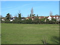
6
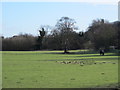
Field between the New River and Lower Road, SG12
Image: © Mike Quinn
Taken: 14 Jan 2015
0.15 miles
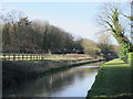
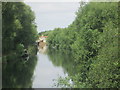
7
The New River north of Cautherly Lane, SG12
See Image
Image: © Mike Quinn
Taken: 14 Jan 2015
0.16 miles
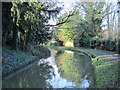
9
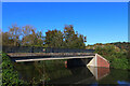
River Lea
Footbridge over the River Lea, near Great Amwell.
Image: © Wayland Smith
Taken: 15 Oct 2023
0.16 miles
10
The New River east of Amwell Hill, SG12 (2)
Image: © Mike Quinn
Taken: 14 Jan 2015
0.17 miles