IMAGES TAKEN NEAR TO
Hoe Lane, WARE, SG12 9NU
Introduction
This page details the photographs taken nearby to Hoe Lane, SG12 9NU by members of the Geograph project.
The Geograph project started in 2005 with the aim of publishing, organising and preserving representative images for every square kilometre of Great Britain, Ireland and the Isle of Man.

There are currently over 7.5m images from over14,400 individuals and you can help contribute to the project by visiting https://www.geograph.org.uk
Image Map
Images are licensed for reuse under creativecommons.org/licenses/by-sa/2.0
Notes
- Clicking on the map will re-center to the selected point.
- The higher the marker number, the further away the image location is from the centre of the postcode.
Image Listing (130 Images Found)
Images are licensed for reuse under creativecommons.org/licenses/by-sa/2.0
Image
Details
Distance
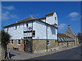
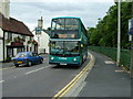
2
School bus in Hoe Lane, Ware
Uno Dennis Dart number 100 turns into Hoe Lane from London Road with the schooldays only 341 journey from Hatfield.
Image: © Rob Candlish
Taken: 21 Jul 2010
0.10 miles
3
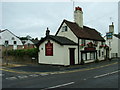
The Royal Oak, London Road, Ware
A busy and popular public house on the corner of Hoe Lane and London Road not far from the railway station.
Image: © Rob Candlish
Taken: 25 Jul 2010
0.11 miles
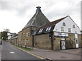
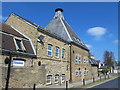
6

Hertford Regional College
New buildings of Hertford Regional College on the corner of Walton Road and London Road. Amwell End and the railway level crossing are just out of shot to the right beyond the pelican crossing.
Image: © Rob Candlish
Taken: 26 Jul 2010
0.13 miles
7
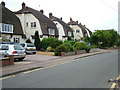
Houses in Walton Road, Ware
Unusually shaped houses in Walton Road, Ware.
Image: © Rob Candlish
Taken: 26 Jul 2010
0.13 miles
8
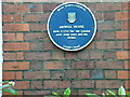
Blue plaque on Amwell House, London Road
The blue plaque placed by Ware Town Council on Amwell House, London Road. A number of other buildings in the town have these plaques as well, including Place House off East Street, the railway station, the old Town Hall and the public library.
Image: © Rob Candlish
Taken: 16 Jul 2010
0.13 miles
9
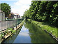
The New River, Ware
The New River is something of a misnomer since it is neither a river nor new. It is an aqueduct built under the direction of Sir Hugh Myddleton between 1607 and 1612 to bring fresh drinking water from Chadwell and Amwell Springs near Ware about 40 miles down the Lee Valley to London. It is seen here with London Road beyond the railings to the left.
Image: © Nigel Cox
Taken: 21 Jun 2006
0.13 miles
10
London Road, Ware
Arriva East Herts & Essex Dennis Trident 5428 (W428XKX) passing “The Royal Oak” public house in London Road, Ware on its way to Waltham Cross. Behind the green railings to the right is the New River.
Image: © Rob Candlish
Taken: 18 Aug 2010
0.13 miles