IMAGES TAKEN NEAR TO
Hillside, WARE, SG12 9JZ
Introduction
This page details the photographs taken nearby to Hillside, SG12 9JZ by members of the Geograph project.
The Geograph project started in 2005 with the aim of publishing, organising and preserving representative images for every square kilometre of Great Britain, Ireland and the Isle of Man.

There are currently over 7.5m images from over14,400 individuals and you can help contribute to the project by visiting https://www.geograph.org.uk
Image Map
Images are licensed for reuse under creativecommons.org/licenses/by-sa/2.0
Notes
- Clicking on the map will re-center to the selected point.
- The higher the marker number, the further away the image location is from the centre of the postcode.
Image Listing (134 Images Found)
Images are licensed for reuse under creativecommons.org/licenses/by-sa/2.0
Image
Details
Distance
2
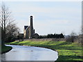
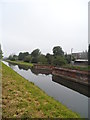
The New River east of Broadmead Pumping Station
Image: © Mike Quinn
Taken: 14 Jan 2015
0.05 miles
3
The New River east of Broadmead Pumping Station (2)
See Image
Image: © Mike Quinn
Taken: 14 Jan 2015
0.05 miles
4
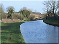
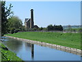
The New River by Hertford Road (A119), SG12 (4)
See Image
Image: © Mike Quinn
Taken: 14 Jan 2015
0.06 miles
5
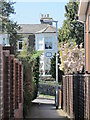
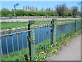
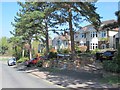
Passageway between Scotts Road and Myddleton Road, SG12
Image: © Mike Quinn
Taken: 23 Apr 2015
0.06 miles
7
The New River east of Broadmead Pumping Station (3)
See Image
Image: © Mike Quinn
Taken: 23 Apr 2015
0.06 miles
8
The New River by Hertford Road (A119), SG12 (2)
See Image
Image: © Mike Quinn
Taken: 14 Jan 2015
0.07 miles
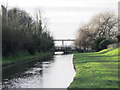
10
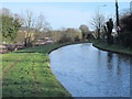
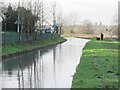
The New River by Hertford Road (A119), SG12 (3)
See Image Looking east towards Amwell End.
Image: © Mike Quinn
Taken: 14 Jan 2015
0.07 miles