IMAGES TAKEN NEAR TO
Railway View, WARE, SG12 9JR
Introduction
This page details the photographs taken nearby to Railway View, SG12 9JR by members of the Geograph project.
The Geograph project started in 2005 with the aim of publishing, organising and preserving representative images for every square kilometre of Great Britain, Ireland and the Isle of Man.

There are currently over 7.5m images from over14,400 individuals and you can help contribute to the project by visiting https://www.geograph.org.uk
Image Map (Loading...)


Getting Data...Please wait
Leaflet Map data © OpenStreetMap
Images are licensed for reuse under creativecommons.org/licenses/by-sa/2.0
Notes
- Clicking on the map will re-center to the selected point.
- The higher the marker number, the further away the image location is from the centre of the postcode.
Image Listing (201 Images Found)
Images are licensed for reuse under creativecommons.org/licenses/by-sa/2.0
Image
Details
Distance
1
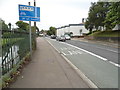
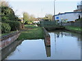
Hertford Road, Ware
Alongside the River Lea
Image: © David Howard
Taken: 10 Jul 2014
0.01 miles
2
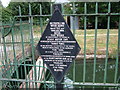
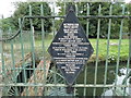
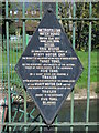
Old Metropolitan Water Board sign
The Metropolitan Water Board was formed in 1903 to unify London's water suppliers. It took over the New River Company and thereby became responsible for the New River. The Board itself was absorbed into the Thames Water Authority in 1973. The New River is now the responsibility of the Environment Agency. This sign has done well to survive.
Image: © Rob Candlish
Taken: 23 Jul 2010
0.01 miles
4
Pre-Worboys weight limit on Hertford Road
These signs were issued under regulations by the bridge owners for the public roads going across them. This bridge is now gated and probably used very rarely by the river authority itself.
Image: © David Howard
Taken: 10 Jul 2014
0.02 miles
5
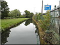
Old sign by the New River near Scotts Road, SG12
The location of this sign is shown in Image
Image: © Mike Quinn
Taken: 23 Apr 2015
0.02 miles
6
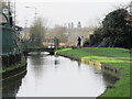
The New River west of Amwell End, SG12
See Image
Image: © Mike Quinn
Taken: 14 Jan 2015
0.03 miles
7
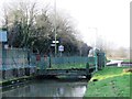
The New River by Hertford Road (A119), SG12
See Image The mid-19th C cast-iron railings on the left (southern) side of the New River, as far as the bridge in the middle distance, are Grade II listed http://list.english-heritage.org.uk/resultsingle.aspx?uid=1217388 .
Image: © Mike Quinn
Taken: 14 Jan 2015
0.03 miles
8
Bridge on the New River by Hertford Road (A119), SG12
See Image The bridge, built in 1817, is Grade II listed http://list.english-heritage.org.uk/resultsingle.aspx?uid=1217386 .
Image: © Mike Quinn
Taken: 14 Jan 2015
0.03 miles
9
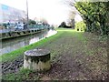
Slipway on the New River in Ware (2)
Image: © Mike Quinn
Taken: 14 Jan 2015
0.03 miles
10
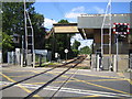
Ware Level Crossing
The Amwell End level crossing to the west of Ware station looking in the direction of Hertford East station. The track is singled through Ware station.
Image: © Nigel Cox
Taken: 21 Jun 2006
0.03 miles