IMAGES TAKEN NEAR TO
Crib Street, WARE, SG12 9HG
Introduction
This page details the photographs taken nearby to Crib Street, SG12 9HG by members of the Geograph project.
The Geograph project started in 2005 with the aim of publishing, organising and preserving representative images for every square kilometre of Great Britain, Ireland and the Isle of Man.

There are currently over 7.5m images from over14,400 individuals and you can help contribute to the project by visiting https://www.geograph.org.uk
Image Map (Loading...)


Getting Data...Please wait
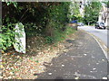
Leaflet Map data © OpenStreetMap
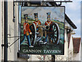
Images are licensed for reuse under creativecommons.org/licenses/by-sa/2.0
Notes
- Clicking on the map will re-center to the selected point.
- The higher the marker number, the further away the image location is from the centre of the postcode.
Image Listing (91 Images Found)
Images are licensed for reuse under creativecommons.org/licenses/by-sa/2.0
Image
Details
Distance
3
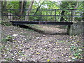
Ware: The Bourne
A bourne is an intermittent stream that only flows when the level of the water table in the ground reaches the surface or when there has been sufficient rainfall to saturate the surrounding land. Most have prefixed names such as "Winter Bourne", but this one is just The Bourne, and the watercourse only runs for a couple of kilometres before joining the River Lee in Ware. At the end of October 2010 the stream bed was totally dry.
Here a footbridge takes the path between Milton Road and Southall Close across the dry stream bed.
Image: © Nigel Cox
Taken: 29 Oct 2010
0.13 miles
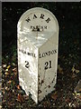
4
Old Milepost
Old milepost on what was the A10 at Ware, Hertfordshire; for close up view see http://www.geograph.org.uk/photo/3207523
Image: © Keith Evans
Taken: 1 Nov 2012
0.15 miles
6
Old Milepost
Old milepost on what was the A10 at Ware, Hertfordshire; for overall view see http://www.geograph.org.uk/photo/3207515
Image: © Keith Evans
Taken: 1 Nov 2012
0.15 miles
7
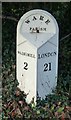
Old Milepost by the A1170, Wadesmill Road, Ware Parish
Cast iron post by the A1170, in parish of WARE (EAST HERTFORDSHIRE District), Wadesmill Road, by Fire Station, in pavement, on West side of road. Ware casting, erected by the Cheshunt turnpike trust in the 19th century.
Inscription reads:-
: WADESMILL / 2 : : WARE / PARISH : : LONDON / 21 :
Grade II Listed. List Entry Number: 1221544
https://historicengland.org.uk/listing/the-list/list-entry/1221544
Milestone Society National ID: HE_LK21.
Image: © MW Hallett
Taken: 25 Mar 2003
0.15 miles
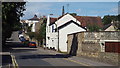
8
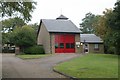
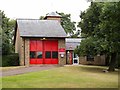
Ware fire station
Ware fire station, Baldock Street, Ware, Hertfordshire
Image: © Kevin Hale
Taken: 7 Oct 2007
0.16 miles
9
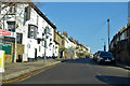
Musley Hill, Ware
Climbing out of the Lea Valley past the Rifle Volunteer pub, near left.
Image: © Robin Webster
Taken: 17 Feb 2019
0.16 miles