IMAGES TAKEN NEAR TO
Hoe Lane, WARE, SG12 9EY
Introduction
This page details the photographs taken nearby to Hoe Lane, SG12 9EY by members of the Geograph project.
The Geograph project started in 2005 with the aim of publishing, organising and preserving representative images for every square kilometre of Great Britain, Ireland and the Isle of Man.

There are currently over 7.5m images from over14,400 individuals and you can help contribute to the project by visiting https://www.geograph.org.uk
Image Map (15 Images)


Getting Data...Please wait
Leaflet Map data © OpenStreetMap
Images are licensed for reuse under creativecommons.org/licenses/by-sa/2.0
Notes
- Clicking on the map will re-center to the selected point.
- The higher the marker number, the further away the image location is from the centre of the postcode.
Image Listing (15 Images Found)
Images are licensed for reuse under creativecommons.org/licenses/by-sa/2.0
Image
Details
Distance
1
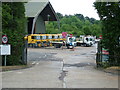
County Council lorries
Hertfordshire Highways vehicles in the depot in Hoe Lane.
Image: © Rob Candlish
Taken: 26 Jul 2010
0.03 miles
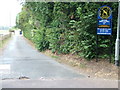
2
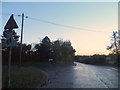
Hoe Lane at the junction of Walnut Tree Walk, Ware
Image: © David Howard
Taken: 1 Nov 2012
0.07 miles
3
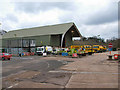
Council Depot
The building is styled on a modern Dutch Barn design, which is used to store salt, used for the roads in winter.
Image: © Melvyn Cousins
Taken: 11 Mar 2006
0.08 miles
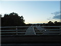
4
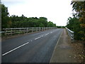
Bridge in Hoe Lane, Ware
The bridge carrying Hoe Lane, Ware over the A10. In the distance is the junction of Hoe Lane and the B1502.
Image: © Rob Candlish
Taken: 26 Jul 2010
0.14 miles
5
Hertford Rugby Football Club
Entrance to Hertford Rugby Football Club's ground which quite paradoxically is in Hoe Lane, Ware.
Image: © Rob Candlish
Taken: 26 Jul 2010
0.14 miles
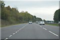
6
The A10 from Hoe Lane, Rush Green
The Hertford turnoff can be seen on the left
Image: © David Howard
Taken: 1 Nov 2012
0.15 miles
8
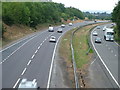
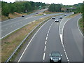
A10 from Hoe Lane bridge, Ware
Morning traffic on the busy A10 trunk road seen from the bridge in Hoe Lane, Ware.
Image: © Rob Candlish
Taken: 26 Jul 2010
0.18 miles
9
A10 near Rush Green
Traffic on the A10 trunk road viewed from Hoe Lane with Rush Green Roundabout in the distance.
Image: © Rob Candlish
Taken: 26 Jul 2010
0.18 miles
10
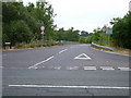
Hoe Lane
Looking down Hoe Lane from the B1502. The A10 passes beneath the bridge which can be seen in Hoe Lane.
Image: © Rob Candlish
Taken: 26 Jul 2010
0.18 miles