IMAGES TAKEN NEAR TO
High Street, WARE, SG12 9DA
Introduction
This page details the photographs taken nearby to High Street, SG12 9DA by members of the Geograph project.
The Geograph project started in 2005 with the aim of publishing, organising and preserving representative images for every square kilometre of Great Britain, Ireland and the Isle of Man.

There are currently over 7.5m images from over14,400 individuals and you can help contribute to the project by visiting https://www.geograph.org.uk
Image Map
Images are licensed for reuse under creativecommons.org/licenses/by-sa/2.0
Notes
- Clicking on the map will re-center to the selected point.
- The higher the marker number, the further away the image location is from the centre of the postcode.
Image Listing (233 Images Found)
Images are licensed for reuse under creativecommons.org/licenses/by-sa/2.0
Image
Details
Distance
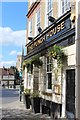
1
Bus stop, High Street
Old meets new in Ware High Street! A 1946 AEC Regent 2 (STL 2692, HGC 225) from London Transport is part of a vintage bus festival and the patient conductor is wearing a full uniform. Overtaking the Regent is a 'demand-responsive' bus (RE21 LRJ) operating a Herts Lynx service for East Herts District Council. How times have changed!
Image: © Jonathan Wilkins
Taken: 7 Apr 2024
0.01 miles
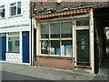
2
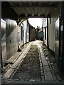
George Walk Ware.
One of several archways off Ware High Street that lead down to The River Lea
Image: © Melvyn Cousins
Taken: 1 Mar 2007
0.02 miles
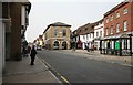
3
High Street Ware Herts
View of part of Ware Town Centre.
Image: © Robert Timms
Taken: 28 Feb 2006
0.02 miles
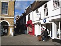
4
Wright's fish and chip shop, East Street, Ware
Widely acclaimed as the best fish and chips in the town, Wright's have won a number of national awards. To the right of the shop is the archway, with the Ware Bluecoat boy statue above it, leading to Bluecoat Yard and Place House.
Image: © Rob Candlish
Taken: 25 Jul 2010
0.03 miles
5
Church Street, Ware
An ivy clad building on the right and a corner of Tesco's on the left. The zebra crossing leads from Tesco's car park.
Image: © Rob Candlish
Taken: 25 Jul 2010
0.03 miles
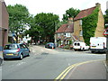
6
Ware High Street
Once the Town Hall now an estate agent, just on the left was the original Tesco I think, way back in the late '70s. Not much traffic is there, don't be fooled, I waited for a gap and it was a long wait. Cars spoil towns like this but what can we do with out them?
Image: © roger geach
Taken: 18 Mar 2010
0.03 miles

8
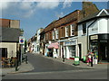
East Street, Ware
Shops in East Street, Ware seen from its junction with New Road. Notice the delivery bike outside the butcher's (the shop with the red and white striped awning).
Image: © Rob Candlish
Taken: 24 Jul 2010
0.04 miles
9
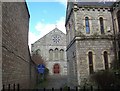
Leaside Church Ware Herts
This picture of Leaside Methodist and United Reformed Church, is viewed from a very narrow alleyway between two shops, in the town centre of Ware in Herts.
Image: © Robert Timms
Taken: 28 Feb 2006
0.04 miles