IMAGES TAKEN NEAR TO
Benningfield Road, WARE, SG12 8RD
Introduction
This page details the photographs taken nearby to Benningfield Road, SG12 8RD by members of the Geograph project.
The Geograph project started in 2005 with the aim of publishing, organising and preserving representative images for every square kilometre of Great Britain, Ireland and the Isle of Man.

There are currently over 7.5m images from over14,400 individuals and you can help contribute to the project by visiting https://www.geograph.org.uk
Image Map (Loading...)


Getting Data...Please wait
Leaflet Map data © OpenStreetMap
Images are licensed for reuse under creativecommons.org/licenses/by-sa/2.0
Notes
- Clicking on the map will re-center to the selected point.
- The higher the marker number, the further away the image location is from the centre of the postcode.
Image Listing (27 Images Found)
Images are licensed for reuse under creativecommons.org/licenses/by-sa/2.0
Image
Details
Distance
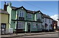
1
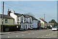
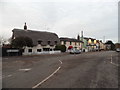
The Green Man, Widford
On the High Street.
Image: © Robin Webster
Taken: 13 Mar 2014
0.05 miles
3
Junction of High Street and Hundson Road Widford
Image: © PAUL FARMER
Taken: 4 Nov 2012
0.05 miles
6
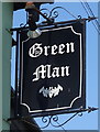
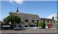
Sign for the Green Man, Widford
See Image] for context.
Image: © JThomas
Taken: 20 Jul 2019
0.05 miles
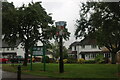
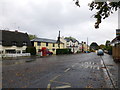
9
Hunsdon Road at the junction of High Street, Widford
Image: © David Howard
Taken: 19 Nov 2017
0.06 miles
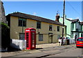
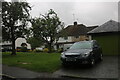
10
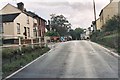
B1004 at Widford
This picture is taken in the north western corner of the gridsquare looking south.
Image: © Simon Davies
Taken: Unknown
0.06 miles