IMAGES TAKEN NEAR TO
Tanners Way, WARE, SG12 8QL
Introduction
This page details the photographs taken nearby to Tanners Way, SG12 8QL by members of the Geograph project.
The Geograph project started in 2005 with the aim of publishing, organising and preserving representative images for every square kilometre of Great Britain, Ireland and the Isle of Man.

There are currently over 7.5m images from over14,400 individuals and you can help contribute to the project by visiting https://www.geograph.org.uk
Image Map (Loading...)


Getting Data...Please wait
Leaflet Map data © OpenStreetMap
Images are licensed for reuse under creativecommons.org/licenses/by-sa/2.0
Notes
- Clicking on the map will re-center to the selected point.
- The higher the marker number, the further away the image location is from the centre of the postcode.
Image Listing (29 Images Found)
Images are licensed for reuse under creativecommons.org/licenses/by-sa/2.0
Image
Details
Distance
4
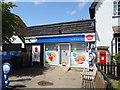
Hunsdon Convenience Store and Post Office
On High Street.
Showing position of Postbox No. SG12 101.
See Image] for postbox.
Image: © JThomas
Taken: 20 Jul 2019
0.14 miles
5
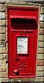
Elizabeth II postbox, Hunsdon Post Office
Postbox No. SG12 101.
See Image] for context.
Image: © JThomas
Taken: 20 Jul 2019
0.14 miles
6

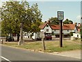
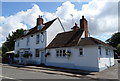
Sign for the Fox & Hounds, Hunsdon
See Image] for context.
Image: © JThomas
Taken: 20 Jul 2019
0.15 miles
8
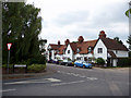
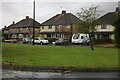
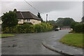
Hunsdon Village, Hertfordshire
Looking across from the War Memorial.
Image: © Christine Matthews
Taken: 15 Aug 2010
0.16 miles