IMAGES TAKEN NEAR TO
Stanstead Road, WARE, SG12 8PS
Introduction
This page details the photographs taken nearby to Stanstead Road, SG12 8PS by members of the Geograph project.
The Geograph project started in 2005 with the aim of publishing, organising and preserving representative images for every square kilometre of Great Britain, Ireland and the Isle of Man.

There are currently over 7.5m images from over14,400 individuals and you can help contribute to the project by visiting https://www.geograph.org.uk
Image Map
Images are licensed for reuse under creativecommons.org/licenses/by-sa/2.0
Notes
- Clicking on the map will re-center to the selected point.
- The higher the marker number, the further away the image location is from the centre of the postcode.
Image Listing (7 Images Found)
Images are licensed for reuse under creativecommons.org/licenses/by-sa/2.0
Image
Details
Distance
2
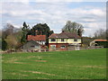
Wingates Cottage and North Cottage at Bonningtons, near Hunsdon
The building in the foreground is Wingates Cottage and the one behind and to the left is North Cottage.
Originally Bonningtons Estate cottages, Wingate being the Butlers Cottage and North being the Head Gardeners, both were sold off into private freehold ownership in the late 1940's.
Image: © Alan Kent
Taken: 10 Apr 2007
0.11 miles
3
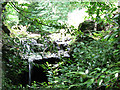
Waterfall at the outlet of a small lake
The waterfall is shown on the Explorer map. It is at the outfall of a small lake by "Bonningtons". The water falls into a culvert under the B180. Towards the end of a dry spell in high summer there was only a trickle.
Image: © Stephen Craven
Taken: 15 Aug 2009
0.16 miles