IMAGES TAKEN NEAR TO
Holly Cross Road, WARE, SG12 8NB
Introduction
This page details the photographs taken nearby to Holly Cross Road, SG12 8NB by members of the Geograph project.
The Geograph project started in 2005 with the aim of publishing, organising and preserving representative images for every square kilometre of Great Britain, Ireland and the Isle of Man.

There are currently over 7.5m images from over14,400 individuals and you can help contribute to the project by visiting https://www.geograph.org.uk
Image Map (10 Images)


Getting Data...Please wait
Leaflet Map data © OpenStreetMap
Images are licensed for reuse under creativecommons.org/licenses/by-sa/2.0
Notes
- Clicking on the map will re-center to the selected point.
- The higher the marker number, the further away the image location is from the centre of the postcode.
Image Listing (10 Images Found)
Images are licensed for reuse under creativecommons.org/licenses/by-sa/2.0
Image
Details
Distance
2
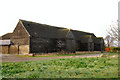
Redundant Barn, Widbury Hill Farm
This redundant barn stands prominently above the level of the road on Widbury Hill towards the eastern outskirts of Ware.
Image: © Rob Candlish
Taken: 26 Jul 2010
0.14 miles
3
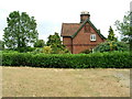
Cottage at Widbury Hill Farm
A cottage at Widbury Hill Farm just outside Ware. Set in the gable end are the arms of the Buxton family.
Image: © Rob Candlish
Taken: 26 Jul 2010
0.16 miles
4
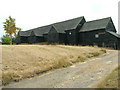
Widbury Hill Farm Barns
A large unused barn complex, part of which was once used for milking.
Image: © Melvyn Cousins
Taken: 30 Nov 2006
0.16 miles
5
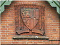
Buxton family arms
Close up of the Buxton family arms moulded in terra cotta tiles and set in the gable end of a cottage at Widbury Hill Farm just outside Ware.
Image: © Rob Candlish
Taken: 26 Jul 2010
0.16 miles
6
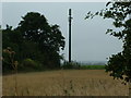
Mobile phone mast
A mobile phone mast in a field on Widbury Hill Farm just outside Ware. This is marked on 1:25,000 Ordnance Survey sheets but not on 1:50,000 ones.
Image: © Rob Candlish
Taken: 26 Jul 2010
0.17 miles
7
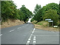
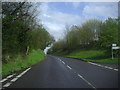
Widbury Hill, Ware
Widbury Hill seen from its junction with Hollycross Road (some street maps spell this incorrectly as "Holly Cross Road").
Image: © Rob Candlish
Taken: 26 Jul 2010
0.21 miles
8
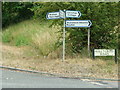
Signpost on Widbury Hill
The bottom line of the left hand sign, which points up the hill, reads "Much Hadham". Widbury Hill is a classified road (B1004) yet its number does not appear on the sign.
Image: © Rob Candlish
Taken: 26 Jul 2010
0.22 miles
9
Widbury Hill at the junction of Hollycross Road, Ware
Image: © David Howard
Taken: 25 Apr 2012
0.22 miles
10
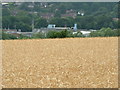
More barley
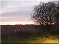
A view from Widbury Hill across a field of barley. In the distance are the factories in Marsh Lane on the valley floor and, right at the top of the photograph, the houses in Presdales Drive on the other side of the Lea Valley in grid square TL3613.
Image: © Rob Candlish
Taken: 26 Jul 2010
0.24 miles