IMAGES TAKEN NEAR TO
Hunsdon Road, WARE, SG12 8LN
Introduction
This page details the photographs taken nearby to Hunsdon Road, SG12 8LN by members of the Geograph project.
The Geograph project started in 2005 with the aim of publishing, organising and preserving representative images for every square kilometre of Great Britain, Ireland and the Isle of Man.

There are currently over 7.5m images from over14,400 individuals and you can help contribute to the project by visiting https://www.geograph.org.uk
Image Map (Loading...)


Getting Data...Please wait
Leaflet Map data © OpenStreetMap
Images are licensed for reuse under creativecommons.org/licenses/by-sa/2.0
Notes
- Clicking on the map will re-center to the selected point.
- The higher the marker number, the further away the image location is from the centre of the postcode.
Image Listing (6 Images Found)
Images are licensed for reuse under creativecommons.org/licenses/by-sa/2.0
Image
Details
Distance
1
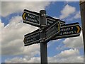
Five footpath direction sign near Stanstead Abbotts
Image: © Ken Amphlett
Taken: 7 Jun 2017
0.14 miles
2
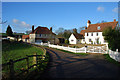
Newlands
Newlands is at the start of the Public Footpath that leads to Little Briggens.
Image: © Melvyn Cousins
Taken: 24 Jan 2007
0.18 miles
4
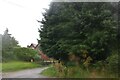
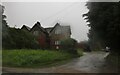
Tree and house by Roydon Road, Stanstead Abbotts
There was nothing wrong with the camera, all that muck is rain.
Image: © David Howard
Taken: 25 Jul 2021
0.23 miles
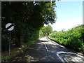
5
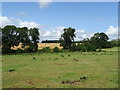
Grazing near Home Farm
Off Hunsdon Road (B180).
Image: © JThomas
Taken: 20 Jul 2019
0.24 miles
6
House on Roydon Road, Stanstead Abbotts
Image: © David Howard
Taken: 25 Jul 2021
0.24 miles