IMAGES TAKEN NEAR TO
Cresset Close, WARE, SG12 8LL
Introduction
This page details the photographs taken nearby to Cresset Close, SG12 8LL by members of the Geograph project.
The Geograph project started in 2005 with the aim of publishing, organising and preserving representative images for every square kilometre of Great Britain, Ireland and the Isle of Man.

There are currently over 7.5m images from over14,400 individuals and you can help contribute to the project by visiting https://www.geograph.org.uk
Image Map
Images are licensed for reuse under creativecommons.org/licenses/by-sa/2.0
Notes
- Clicking on the map will re-center to the selected point.
- The higher the marker number, the further away the image location is from the centre of the postcode.
Image Listing (39 Images Found)
Images are licensed for reuse under creativecommons.org/licenses/by-sa/2.0
Image
Details
Distance
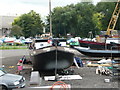
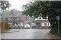
2
Old cottages on Hoddesdon Road, St Margarets
Image: © David Howard
Taken: 25 Jul 2021
0.11 miles
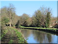
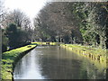
4
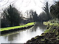
The New River south of High Street, Stanstead St. Margaret's, SG12
See Image
Image: © Mike Quinn
Taken: 14 Jan 2015
0.15 miles
8
The New River south of High Street, Stanstead St. Margaret's, SG12
See Image
Image: © Mike Quinn
Taken: 14 Jan 2015
0.18 miles
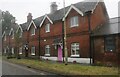
9
Hoddesdon Road, St Margarets
This is an access road to the houses only.
Image: © David Howard
Taken: 25 Jul 2021
0.18 miles
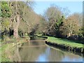
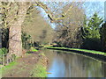
10
The New River south of High Street, Stanstead St. Margaret's, SG12 (4)
Image: © Mike Quinn
Taken: 14 Jan 2015
0.18 miles