IMAGES TAKEN NEAR TO
Netherfield Court, WARE, SG12 8HP
Introduction
This page details the photographs taken nearby to Netherfield Court, SG12 8HP by members of the Geograph project.
The Geograph project started in 2005 with the aim of publishing, organising and preserving representative images for every square kilometre of Great Britain, Ireland and the Isle of Man.

There are currently over 7.5m images from over14,400 individuals and you can help contribute to the project by visiting https://www.geograph.org.uk
Image Map (Loading...)


Getting Data...Please wait
Leaflet Map data © OpenStreetMap
Images are licensed for reuse under creativecommons.org/licenses/by-sa/2.0
Notes
- Clicking on the map will re-center to the selected point.
- The higher the marker number, the further away the image location is from the centre of the postcode.
Image Listing (11 Images Found)
Images are licensed for reuse under creativecommons.org/licenses/by-sa/2.0
Image
Details
Distance
1
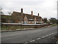
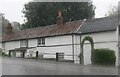
Stanstead Abbotts: Sir Edward Baesh's almshouses
The almshouses on Roydon Road were endowed under the terms of the will of Sir Edward Baesh in 1653. The almshouses and their forecourt wall are Grade II* Listed. The English Heritage Listed Building website describes them as follows:-
"Red brick in English-bond with a long steep old red tiled roof. A single storey row of 3 handed pairs of almshouses facing NW. Each pair has 2 plank doors together, in a heavy chamfered wooden frame, a 3-light ovolo-moulded casement window with ironcentral opening light for each house, a gable over the door with a single small 2-light ovolo-moulded window with leaded lattice glazing, and a shared central chimney with a pair of diagonally set shafts. Toothed corbel course below the eaves and low plastered plinth. Modern single-storey small additions at rear and each end. Red brick wall around elongated forecourt garden, taller at ends, reduced at front but with heavy sloped brick coping reinstated. Square gatepiers with stone caps and C20 wrought iron gate. A landmark at a bend in the road at the S end of the village."
The Listed Buildings website also describes them as The Baish Almshouses.
Image: © Nigel Cox
Taken: 1 Dec 2010
0.09 miles
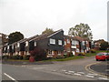
2
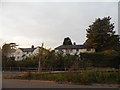
Houses on Hunsdon Road, Stanstead Abbotts
The one on the right has WRDC on it (not legible), probably standing for Ware Regional District Council.
Image: © David Howard
Taken: 15 Oct 2015
0.13 miles
3
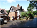
Wooden house on Roydon Road, Stanstead Abbotts
It's clearly waterproof
Image: © David Howard
Taken: 25 Jul 2021
0.13 miles
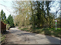
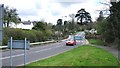
4
Thele Close at the junction of the B181
Image: © David Howard
Taken: 15 Oct 2015
0.14 miles
6
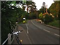
The cyclist knows which road they'd rather take!
Downhill to Hunsford on the B180, or uphill to Roydon on the B181.
Image: © Colin Bell
Taken: 5 Jun 2008
0.15 miles
7

House on Roydon Road, Stanstead Abbotts
Image: © David Howard
Taken: 25 Jul 2021
0.15 miles
8

Roydon Road, Stanstead Abbotts
Had I known what the weather would do I might have stayed at home. However the photos which did come out well were very dramatic and unusual.
Image: © David Howard
Taken: 25 Jul 2021
0.18 miles