IMAGES TAKEN NEAR TO
Easneye, WARE, SG12 8DB
Introduction
This page details the photographs taken nearby to Easneye, SG12 8DB by members of the Geograph project.
The Geograph project started in 2005 with the aim of publishing, organising and preserving representative images for every square kilometre of Great Britain, Ireland and the Isle of Man.

There are currently over 7.5m images from over14,400 individuals and you can help contribute to the project by visiting https://www.geograph.org.uk
Image Map
Images are licensed for reuse under creativecommons.org/licenses/by-sa/2.0
Notes
- Clicking on the map will re-center to the selected point.
- The higher the marker number, the further away the image location is from the centre of the postcode.
Image Listing (6 Images Found)
Images are licensed for reuse under creativecommons.org/licenses/by-sa/2.0
Image
Details
Distance
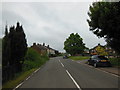
2
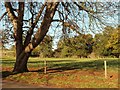
Hertfordshire countryside in glorious autumn sunshine
The picture was taken from Holly Cross Road as you leave Stanstead Abbotts and head towards Ware.
Image: © Robert Edwards
Taken: 24 Oct 2008
0.09 miles
3
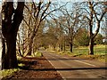
A lovely autumn day along Holly Cross Road
Image: © Robert Edwards
Taken: 24 Oct 2008
0.11 miles
5
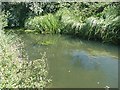
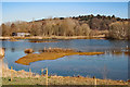
Stanstead Mill Stream at Amwell Magna
Away from the Lee Navigation the River Lee is more natural. This shows the Stanstead Mill Stream soon after it splits from the River Lee at a weir within the Amwell Magna fishery. It rejoins the Lee in the navigable waters below Stanstead Abbotts.
Image: © David Leeming
Taken: 15 Aug 2001
0.15 miles