IMAGES TAKEN NEAR TO
South Street, WARE, SG12 8AJ
Introduction
This page details the photographs taken nearby to South Street, SG12 8AJ by members of the Geograph project.
The Geograph project started in 2005 with the aim of publishing, organising and preserving representative images for every square kilometre of Great Britain, Ireland and the Isle of Man.

There are currently over 7.5m images from over14,400 individuals and you can help contribute to the project by visiting https://www.geograph.org.uk
Image Map (Loading...)


Getting Data...Please wait
Leaflet Map data © OpenStreetMap
Images are licensed for reuse under creativecommons.org/licenses/by-sa/2.0
Notes
- Clicking on the map will re-center to the selected point.
- The higher the marker number, the further away the image location is from the centre of the postcode.
Image Listing (33 Images Found)
Images are licensed for reuse under creativecommons.org/licenses/by-sa/2.0
Image
Details
Distance
1
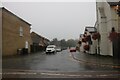
Millers Lane, Stanstead Abbotts
In very heavy rain
Image: © David Howard
Taken: 25 Jul 2021
0.06 miles
2
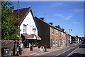
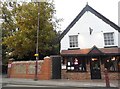
The Abbotts Spice
Curry House in Stanstead Abbotts High Street. The terrace beyond is Hope Cottages dating from 1886.
Image: © Des Blenkinsopp
Taken: 13 Sep 2012
0.08 miles
3
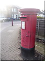
Stanstead Abbotts: postbox № SG12 53, High Street
This large postbox was probably moved here when the post office relocated, a few years ago, from High Street premises a few doors behind us. The post office is now contained within the Co-Op store a short distance ahead on the other side.
Image: © Chris Downer
Taken: 6 Jan 2014
0.08 miles
4
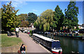
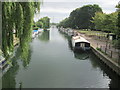
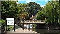
Lea Navigation at Stanstead Abbotts
Image: © Des Blenkinsopp
Taken: 13 Sep 2012
0.09 miles
5
Indian restaurant in Stanstead Abbotts
It was the Spice Cottage but has changed its name to Taste of the Raj.
Image: © David Howard
Taken: 15 Oct 2015
0.09 miles
7
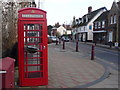
Stanstead Abbotts: redundant telephone box
No longer containing its telephone equipment, this phone box nevertheless remains a feature of the High Street and has a hanging basket on three sides, presumably a colourful display in the summer.
Image: © Chris Downer
Taken: 6 Jan 2014
0.10 miles
8
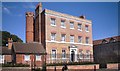
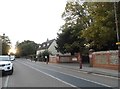
House and Turret
This is Stanstead Hall, listed Grade II*, Historic England reference 1078756. It dates from 1752, although the tower is an early C19th addition and contains a circular iron staircase for the servants. Further information at http://list.historicengland.org.uk/resultsingle.aspx?uid=1078756. (Historic England is the former part of English Heritage that now deals with Listed buildings legislation.)
Image: © Des Blenkinsopp
Taken: 13 Sep 2012
0.10 miles
9
The B181, Stanstead Abbotts
The road surface design could best be described as eccentric. I hope no pedestrians or cyclists actually think the middle strip is for their usage. I prefer the astroturf stripes recently added in Tolworth, although it also involved a serious road narrowing as well.
Image: © David Howard
Taken: 15 Oct 2015
0.10 miles
10
River Lee Navigation at St. Margaret's
Image: © Malc McDonald
Taken: 3 Aug 2013
0.11 miles