IMAGES TAKEN NEAR TO
Cold Christmas Lane, WARE, SG12 7SP
Introduction
This page details the photographs taken nearby to Cold Christmas Lane, SG12 7SP by members of the Geograph project.
The Geograph project started in 2005 with the aim of publishing, organising and preserving representative images for every square kilometre of Great Britain, Ireland and the Isle of Man.

There are currently over 7.5m images from over14,400 individuals and you can help contribute to the project by visiting https://www.geograph.org.uk
Image Map (Loading...)


Getting Data...Please wait
Leaflet Map data © OpenStreetMap
Images are licensed for reuse under creativecommons.org/licenses/by-sa/2.0
Notes
- Clicking on the map will re-center to the selected point.
- The higher the marker number, the further away the image location is from the centre of the postcode.
Image Listing (9 Images Found)
Images are licensed for reuse under creativecommons.org/licenses/by-sa/2.0
Image
Details
Distance
1
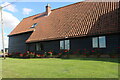
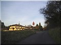
Converted barn at Swangles Farm, Cold Christmas
Image: © David Howard
Taken: 9 Jul 2023
0.00 miles
2
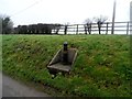
Bollard marking the Greenwich Meridian
The plaque says that this marker was installed in 1984.
Image: © Bikeboy
Taken: 15 Feb 2015
0.02 miles
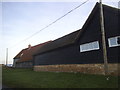
4
Converted barn at Swangles Farm, Cold Christmas
Image: © David Howard
Taken: 9 Jul 2023
0.02 miles
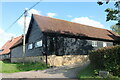
5
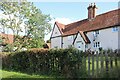
Cottage by Swangles Farm, Cold Christmas
Image: © David Howard
Taken: 9 Jul 2023
0.03 miles
6
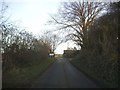
Entering Cold Christmas
It is usually cold here at Christmas but it probably means something different.
Image: © David Howard
Taken: 16 Feb 2016
0.06 miles
7
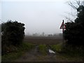
Footpath towards Fabdens
A misty morning in February
Image: © Bikeboy
Taken: 15 Feb 2015
0.18 miles
9
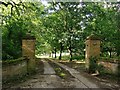
Drive leading to Fabdens
Looking north from Cold Christmas Lane.
Image: © Stefan Czapski
Taken: 11 Aug 2013
0.25 miles