IMAGES TAKEN NEAR TO
Wareside, WARE, SG12 7RG
Introduction
This page details the photographs taken nearby to SG12 7RG by members of the Geograph project.
The Geograph project started in 2005 with the aim of publishing, organising and preserving representative images for every square kilometre of Great Britain, Ireland and the Isle of Man.

There are currently over 7.5m images from over14,400 individuals and you can help contribute to the project by visiting https://www.geograph.org.uk
Image Map (Loading...)


Getting Data...Please wait
Leaflet Map data © OpenStreetMap
Images are licensed for reuse under creativecommons.org/licenses/by-sa/2.0
Notes
- Clicking on the map will re-center to the selected point.
- The higher the marker number, the further away the image location is from the centre of the postcode.
Image Listing (6 Images Found)
Images are licensed for reuse under creativecommons.org/licenses/by-sa/2.0
Image
Details
Distance
1
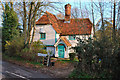
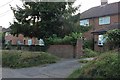
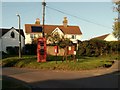
The Crooked Chimneys Cottage
A charming cottage at the junction in Babbs Green
Image: © Melvyn Cousins
Taken: 23 Nov 2006
0.20 miles
3
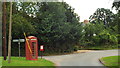
The telephone box at Babbs Green
The road to the left leads to Ware and the road to the right goes to Bakers End.
Image: © Robert Edwards
Taken: 24 Oct 2008
0.22 miles
4
Wareside, near Ware
Wareside is a small village near Ware, in Hertfordshire.
Image: © Malc McDonald
Taken: 3 Aug 2013
0.22 miles