IMAGES TAKEN NEAR TO
Wareside, WARE, SG12 7QR
Introduction
This page details the photographs taken nearby to SG12 7QR by members of the Geograph project.
The Geograph project started in 2005 with the aim of publishing, organising and preserving representative images for every square kilometre of Great Britain, Ireland and the Isle of Man.

There are currently over 7.5m images from over14,400 individuals and you can help contribute to the project by visiting https://www.geograph.org.uk
Image Map (Loading...)


Getting Data...Please wait
Leaflet Map data © OpenStreetMap
Images are licensed for reuse under creativecommons.org/licenses/by-sa/2.0
Notes
- Clicking on the map will re-center to the selected point.
- The higher the marker number, the further away the image location is from the centre of the postcode.
Image Listing (15 Images Found)
Images are licensed for reuse under creativecommons.org/licenses/by-sa/2.0
Image
Details
Distance
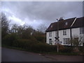
2
The B1004, Wareside
By the road to Babbs Green
Image: © David Howard
Taken: 25 Jul 2021
0.18 miles
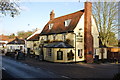
3
Streetscene, Wareside, Herts
The other side of the bend from Image
Image: © Des Blenkinsopp
Taken: 13 Sep 2012
0.19 miles
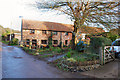
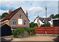
4

Former Wesleyan chapel, Wareside
Converted into residential accommodation.
Image: © Jim Osley
Taken: 30 Jul 2016
0.19 miles
6
Corner of Bakers Lane and Ware Road, Wareside
Image: © David Howard
Taken: 25 Apr 2012
0.19 miles
8

Wareside : war memorial
Grade II listed war memorial, described at this https://historicengland.org.uk/listing/the-list/list-entry/1432105.
Image: © Jim Osley
Taken: 22 Nov 2018
0.20 miles
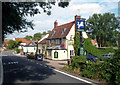
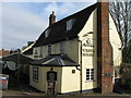
10
Red Lion Behind The Chequers
Almost in the back yard of The Chequers Inn Image still a popular village local, is the old Red Lion which shut years ago.
Image: © Des Blenkinsopp
Taken: 13 Sep 2012
0.21 miles