IMAGES TAKEN NEAR TO
Widbury Hill, WARE, SG12 7QH
Introduction
This page details the photographs taken nearby to Widbury Hill, SG12 7QH by members of the Geograph project.
The Geograph project started in 2005 with the aim of publishing, organising and preserving representative images for every square kilometre of Great Britain, Ireland and the Isle of Man.

There are currently over 7.5m images from over14,400 individuals and you can help contribute to the project by visiting https://www.geograph.org.uk
Image Map (Loading...)


Getting Data...Please wait
Leaflet Map data © OpenStreetMap
Images are licensed for reuse under creativecommons.org/licenses/by-sa/2.0
Notes
- Clicking on the map will re-center to the selected point.
- The higher the marker number, the further away the image location is from the centre of the postcode.
Image Listing (4 Images Found)
Images are licensed for reuse under creativecommons.org/licenses/by-sa/2.0
Image
Details
Distance
1
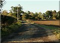
Public bridleway leading to Priorswood
Image: © Robert Edwards
Taken: 24 Oct 2008
0.04 miles
2
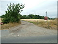
The drive to Priorswood
Seen from the B1004 this is the drive leading to Priorswood (which is marked as Priorswood Cottage on 1:25,000 Ordnance Survey sheets).
Image: © Rob Candlish
Taken: 26 Jul 2010
0.10 miles
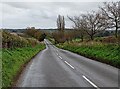
4
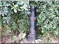
One foot in each hemisphere!
A Greenwich Meridian centenary marker post showing where the meridian crosses the B1004 between Priorswood Cottage and Watersplace Farm.
The plaque on it reads "Greenwich Meridian centenary year 1984".
Image: © Rob Candlish
Taken: 26 Jul 2010
0.20 miles