IMAGES TAKEN NEAR TO
Hampden Hill, WARE, SG12 7JY
Introduction
This page details the photographs taken nearby to Hampden Hill, SG12 7JY by members of the Geograph project.
The Geograph project started in 2005 with the aim of publishing, organising and preserving representative images for every square kilometre of Great Britain, Ireland and the Isle of Man.

There are currently over 7.5m images from over14,400 individuals and you can help contribute to the project by visiting https://www.geograph.org.uk
Image Map (Loading...)


Getting Data...Please wait
Leaflet Map data © OpenStreetMap
Images are licensed for reuse under creativecommons.org/licenses/by-sa/2.0
Notes
- Clicking on the map will re-center to the selected point.
- The higher the marker number, the further away the image location is from the centre of the postcode.
Image Listing (2 Images Found)
Images are licensed for reuse under creativecommons.org/licenses/by-sa/2.0
Image
Details
Distance
1
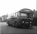
Fanhams Road, Ware
London Country RF604 (NLE604) a 1953 Metro-Cammell bodied AEC Regal IV in Fanhams Road on Hertford and Ware town service route 395A. The junction with Cundalls Road is immediately behind the bus.
The incorrect chalked destination display reading simply "395" seems to indicate that the correct blind could not be found by Hertford Garage. When this photograph was taken route 395A was only operated by single deckers on Sundays, for the rest of the week it was a double deck route.
Image: © Rob Candlish
Taken: Unknown
0.21 miles